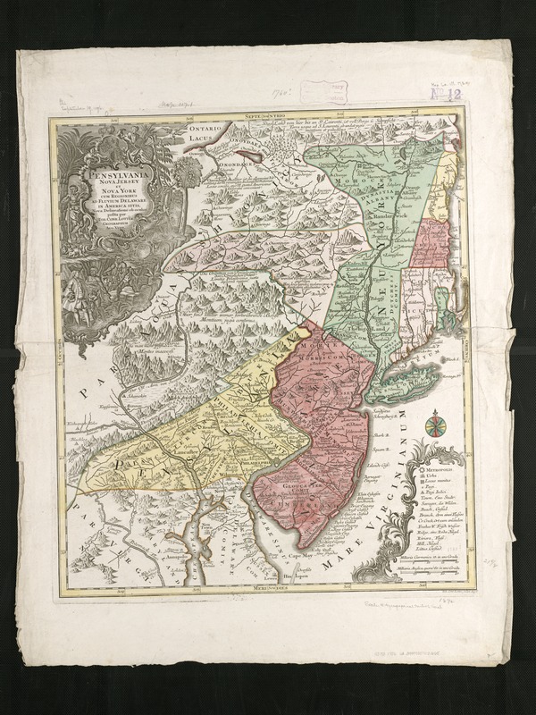
Pensylvania Nova Jersey et Nova York cum Regionibus ad Fluvium Delaware in America sitis
This map is also available in American Revolutionary Geographies Online (ARGO), a collections portal especially built for material relating to the American Revolutionary War Era. Visit ARGO to learn more about this item and explore the historical geography of North America in the late eighteenth century.
Item Information
- Title:
- Pensylvania Nova Jersey et Nova York cum Regionibus ad Fluvium Delaware in America sitis
- Creator:
- Lotter, Tobias Conrad, 1717-1777
- Name on Item:
-
nova delineatione ob oculos posita per Tob. Conr. Lotter.
- Date:
-
[1756–1778]
- Format:
-
Maps/Atlases
- Location:
-
Boston Public Library
Norman B. Leventhal Map & Education Center - Collection (local):
-
Norman B. Leventhal Map & Education Center Collection
- Subjects:
-
Middle Atlantic States--Maps--Early works to 1800
Pennsylvania--Maps--Early works to 1800
New Jersey--Maps--Early works to 1800
New York (State)--Maps--Early works to 1800
- Places:
-
Pennsylvania
Middle Atlantic (area)
New York
New Jersey
- Extent:
- 1 map : col. ; 55 x 48 cm.
- Terms of Use:
-
No known copyright restrictions.
No known restrictions on use.
- Publisher:
-
Aug. Vind :
[Tob. Conr. Lotter]
- Scale:
-
Scale [ca. 1:1,000,000].
- Language:
-
Latin
- Notes:
-
Relief shown pictorially.
Also covers New England (distorted) and northern Chesapeake region.
Title in Latin; notes in German and Latin; legend in Latin, German, and English.
According to T.R. Smith published sometime between the death of Matthaeus Seutter in 1756 and its appearance in Atlas géographique, 1778.
Appears in: Atlas géographique de cent et huit cartes générales et spéciales, 1778.
Includes notes in map area, ill. in title cartouche, and coat-of-arms at head of title.
- Notes (date):
-
This date is inferred.
- Identifier:
-
06_01_006247
- Call #:
-
G3790 1756 .L68
- Barcode:
-
39999059021665
![La Pensilvania, la Nuova York, il Jersey Settentrio[na]le](https://bpldcassets.blob.core.windows.net/derivatives/images/commonwealth:z603vq53g/image_thumbnail_300.jpg)

![An exact map of New Jersey, Pensylvania [sic], New York, Maryland & Virginia, from the latest surveys](https://bpldcassets.blob.core.windows.net/derivatives/images/commonwealth:z603vp67m/image_thumbnail_300.jpg)

