Toggle navigation
LMEC Home
Exhibitions
Georeferencing
Tools for Teachers
Collections
My Favorites
Sign Up / Log In
Search
Search the map portal
Map Collection
Map Collection
Map Sets
Search
Search
Search for
Search In
All Fields
Creator
Title
Subject
Place
Search All Digital Collections
Advanced Search
8549 Results
My Search
Start Over
More Like
commonwealth:4m90fp41x
Remove constraint More Like: commonwealth:4m90fp41x
Filter your Search
Place
North and Central America
5,845
United States
4,769
Massachusetts
2,052
Europe
1,358
Suffolk (county)
1,034
Boston
1,007
Canada
448
Asia
422
more
Place
»
Topic
Boston (Mass.)--Maps
577
United States--Maps
273
Real property--Massachusetts--Boston--Maps
174
Massachusetts--Maps
160
Landowners--Massachusetts--Boston--Maps
132
North America--Maps--Early works to 1800
103
New England--Maps
99
Europe--Maps
78
more
Topic
»
Date
Date range begin
–
Date range end
Current results range from
1482
to
2023
View distribution
Creator
United States. Hydrographic Office
594
O.H. Bailey & Co
148
Des Barres, Joseph F. W. (Joseph Frederick Wallet), 1722-1824
123
United States. Post Office Dept
120
Ptolemy, 2nd cent
100
Walling, Henry Francis, 1825-1888
94
Geological Survey (U.S.)
86
Jefferys, Thomas, -1771
85
more
Creator
»
Format
Maps/Atlases
8,490
Manuscripts
215
Prints
56
Books
36
Objects/Artifacts
10
Drawings/Illustrations
8
Posters
4
Georeferenced
Yes
869
No
7,680
Collection
Norman B. Leventhal Map & Education Center Collection
8,549
Boston and New England Maps
2,204
Urban Maps
1,936
Maritime Charts and Atlases
1,081
American Revolutionary War-Era Maps
616
Boston Redevelopment Authority Collection
87
Available to use
No known restrictions
8,408
Creative Commons license
46
Search Constraints
Sort by relevance
relevance
title
date (asc)
date (desc)
Number of results to display per page
100 per page
10
per page
20
per page
50
per page
100
per page
View results as:
grid view
map view
Search Results
601.
Baltic Basin
602.
Baltic provinces
603.
Baltic Sea : additional plans to chart no. 293
604.
Bancroft's map of the Rocky Mountain states, and the Pacific coast
605.
Bancroft's official guide map of city and county of San Francisco : compiled from official maps in Surveyor's Office
606.
Bancroft's official guide map of city and county of San Francisco
607.
Bancroft's official guide map of city and county of San Francisco : compiled from official maps in Surveyor's Office
608.
Bancroft's official guide map of city and county of San Francisco
609.
Bangor : Pennsylvania
610.
Bangor & Aroostook Railroad and connections : including northern Maine hunting and fishing region
611.
Barbadoes
612.
Barbados
613.
Barbaria
614.
Barbariae et Guineae maritimi à freto Gibraltar ad fluvium Gambiae cum Insulis Salfis Flandrisis et Canaricis
615.
Barre, Washington County, Vt : 1884
616.
La Barrière anti-Germanique
617.
Barrington Bay
618.
Barrio Reus plano general y demostrativo de la ubicacion del barrio, subdivision de los terrenos, etc
619.
Barron County, Wis.
620.
Bartholomew's chart of the world on Mercator's projection
621.
Bartholomew's pocket plan of Edinburgh & suburbs
622.
Bartholomew's tourist's map of South Africa prepared from the latest surveys
623.
Bartlett's illustrated map of Boston, or, Stranger's guide showing the public buildings, places of amusement & its'...
624.
Barton Street, West End
625.
Barton, Vt
626.
Base map of Illinois
627.
Base-map of the United States
628.
Bataan
629.
Bath, Penn
630.
Baton Rouge
631.
The battle fields and military positions in the Virginian peninsula : from surveys supplied by officers of the army
632.
Battle of Brandywine in which the rebels were defeated, September the 11th. 1777, by the army under the command of General Sr....
633.
Battle of Cerro Gordo, April 17th & 18th 1847
634.
Battle of Gravelotte, August 18th, 1870
635.
Battle of Zorndorf
636.
Battlefield in front of Franklin, Tenn. where the United States forces, consisting of the 4th & 23rd Corps and the Cavalry...
637.
Battlefield of Chattanooga with the operations of the national forces under the command of Maj. Gen. U.S. Grant during the...
638.
Battlefield of Chattanooga with the operations of the national forces under the command of Maj. Gen. U.S. Grant during the...
639.
The battlefield of Fredericksburg
640.
The battle-field of the nations : a panoramic view of the seat of war in the Danubian provinces, Turkey, Asia Minor, Southern...
641.
Battlefields in front of Nashville where the United States forces commanded by Major General Geo. H. Thomas defeated and routed...
642.
Battles of Mexico : survey of the line of operations of the U.S. Army, under command of Major General Winfield Scott, on the...
643.
Bauzonenplan von Frankfurt a. M : zur polizeiverordnung betreffend das bauen in der aufsenstadt Frankfurt a. M. vom 8 April 1910
644.
Bavariae Palatinatus vulgo die Ober-Pfaltz in subjacentes ejusdem praefecturas accuratissime divisus
645.
Bavariae pars inferior cum insertis et adjacentibus regionibus non solum in ejusdem ditiones generales sed etiam in earundem...
646.
Bavariae pars superior cum insertis et adjacentibus regionibus non solum in ejusdem ditiones genrales sed etiam in earundem...
647.
Bay Bulls
648.
Bay of Avatcha and approaches
649.
Bay of Avatcha and approaches
650.
Bay of Chaleurs
651.
Bay of Massefao, island of Tutuila ; Bay of Fagaitui, island of Tutuila ; Sketch of Aluau Bay, 1839 ; Sketch of Anuu Island, 1839
652.
Bay of Massefao, island of Tutuila ; Bay of Fagaitui, island of Tutuila ; Sketch of Aluau Bay, 1839 ; Tutuila Isld., approaches...
653.
[Bay of Seven Islands]
654.
Bay State Street Ry. Co's lines and connections
655.
The Bear Garden, the Globe Theatre
656.
La Beauce
657.
Beaufort Harbor and coast line between Charleston S.C. and Savanna Ga : with 5 mile distance lines in circles round Beaufort...
658.
Becket
659.
Becket, Mass
660.
Beddington, Surrey : plan of Croydon sewage farm
661.
Bedford Co., Pa
662.
Bedford irrigation farm
663.
Begin with sense, of ev'ry art the soul, parts answ'ring parts shall slide into a whole
664.
The beginnings of ancient China, 1900-1300 B.C.
665.
Behring's Sea and Arctic Ocean : from surveys of the U.S. North Pacific Surveying Expedition in 1855, Commander John Rodgers,...
666.
Being a cartograph of Ohio : the oldest state west of the thirteen original colonies; now the fourth state in the Union in...
667.
Being a map of the United States in the year 1831 when the Country Gentleman first made its appearance as the Genesee Farmer
668.
Belgii veteris typus
669.
Bellovaci et Silvanectes : les Eveschés de Beauvais et Senlis : Comté et Pairrie de Beauvais : Les Balliages de Beauvais,...
670.
Bellows Falls, Vt
671.
Belvidere : New Jersey
672.
Belvidere Park : Lowell, Mass
673.
Bennett's tourists' route map of Norway
674.
Bennington, N.H : 1887
675.
Bennington, Vt : [1887]
676.
Berkeley Street community garden
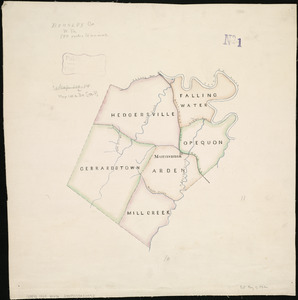
677.
Berkley Co., W. Va
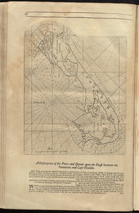
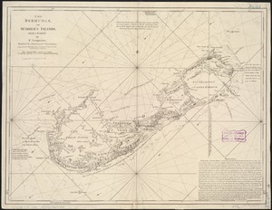
678.
Berlin Falls, N.H., and Berlin Mills : 1888
679.
Bermudas
680.
The Bermudas, or Summer's Islands
681.
Bern
682.
Berwick : Pennsylvania
683.
Beschryvinghe der eylanden van Cuba, Hispaniola, Iamaica, S. Ioannis ende Margarita
684.
Bethel, Vt : 1886
685.
Bicycle map of Massachusetts
686.
Bicycle map of north eastern Massachusetts
687.
Bicycle map of south eastern Massachusetts
688.
Bicycle map of western Massachusetts
689.
Bigini or Pescadores Island ; Radogala and Korsakoff Islands
690.
Bird's eye view and sketch of house lots for sale on Norfolk Hills in Braintree & Weymouth : belonging to Messrs A.H. Hews and...
691.
Bird's eye view of Appleton, Wis : 1874
692.
Bird's eye view of Asbury Park, N.J
693.
Bird's eye view of Bar Harbor, Mount Desert Island, Hancock Co., Maine, 1886
694.
Bird's eye view of Blackstone, Mass : 1879
695.
Bird's eye view of Boston
696.
Bird's eye view of Boston
697.
Bird's eye view of Boston
698.
Bird's eye view of Boston
699.
Bird's eye view of Boston Harbor and south shore to Provincetown showing steamboat routes
700.
Bird's eye view of Bristol, R.I : 1877
‹ Prev
Next ›
1
2
3
4
5
6
7
8
9
10
11
…
85
86