Toggle navigation
LMEC Home
Exhibitions
Georeferencing
Tools for Teachers
Collections
My Favorites
Sign Up / Log In
Search
Search the map portal
Map Collection
Map Collection
Map Sets
Search
Search
Search for
Search In
All Fields
Creator
Title
Subject
Place
Search All Digital Collections
Advanced Search
2888 Results
My Search
Start Over
atlas
Remove constraint atlas
Filter your Search
Place
North and Central America
1,673
United States
1,009
Europe
470
Massachusetts
359
Canada
271
South America
193
Asia
192
Suffolk (county)
165
more
Place
»
Topic
Landowners--Massachusetts--Boston--Maps
115
Real property--Massachusetts--Boston--Maps
106
United States--Maps
87
Boston (Mass.)--Maps
64
United States--History--French and Indian War, 1754-1763--Maps
63
Saint Lawrence River--Maps
41
Nautical charts--Early works to 1800
39
North America--Maps--Early works to 1800
36
more
Topic
»
Date
Date range begin
–
Date range end
Current results range from
1482
to
2023
View distribution
Creator
United States. Hydrographic Office
584
Des Barres, Joseph F. W. (Joseph Frederick Wallet), 1722-1824
118
Ptolemy, 2nd cent
100
Bromley, George Washington
99
Bromley, Walter Scott
97
G.W. Bromley & Co.
75
Carey, Mathew, 1760-1839
74
Paullin, Charles Oscar, 1868 or 1869-1944
70
more
Creator
»
Format
Maps/Atlases
2,872
Manuscripts
58
Books
37
Prints
8
Documents
5
Drawings/Illustrations
1
Georeferenced
Yes
142
No
2,746
Collection
Norman B. Leventhal Map & Education Center Collection
2,431
Maritime Charts and Atlases
1,169
American Revolutionary War-Era Maps
504
Boston and New England Maps
386
Urban Maps
271
Massachusetts Real Estate Atlases
144
William L. Clements Library Collection
92
Mapping Boston Collection
61
more
Collection
»
Available to use
No known restrictions
2,337
Creative Commons license
158
Search Constraints
Sort by relevance
relevance
title
date (asc)
date (desc)
Number of results to display per page
20 per page
10
per page
20
per page
50
per page
100
per page
View results as:
grid view
map view
Search Results
1501.
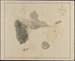
North Atlantic Ocean, Windward Islands, Guadeloupe and adjacent islands : from a French survey of 1867 to 1869
1502.
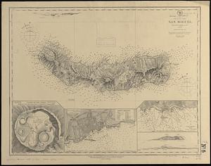
North Atlantic--Azores, San Miguel : from a British survey in 1844
1503.
The north coast of the Gulf of Mexico, from St. Marks to Galveston
1504.
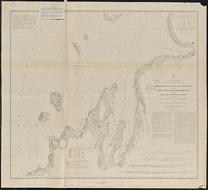
North east end of Lake Michigan including Grand and Little Traverse Bays and the Fox and Manitou Islands
1505.
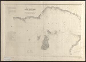
North end of Lake Michigan including Green Bay and the straits of Mackinac
1506.
North end of Lake Michigan including the Beaver Island group
1507.
North end of Lake Michigan including the Beaver Island group
1508.
North Pacific
1509.
North Pacific islands
1510.
North Pacific Islands
1511.
North Pacific islands
1512.
North Pacific Ocean
1513.
North Pacific Ocean
1514.
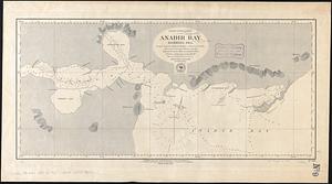
North Pacific Ocean, Anadir Bay, Behring Sea : from a chart by Engineer Bulkley of New York in 1865, with corrections and...
1515.
North Pacific Ocean, atolls in the Marshall Group : from an examination by the U.S.S. "Narragansett", Comdr. R.W. Meade, in 1872
1516.
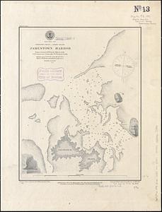
North Pacific Ocean, Caroline Group - Ponapi Island, Jamestown Harbor : from a survey in 1870 by the officers of the U.S.S....
1517.
North Pacific Ocean-- Caroline Is., Ascension I. (Pouinipet or Ponape I.), Kiti Harbor
1518.
North Pacific Ocean, Caroline Islands, Seniavine Islands : from French, Russian and U.S. surveys, corrected to 1873
1519.
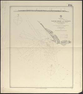
North Pacific Ocean, coast of Mexico, preliminary, Tartar Shoal and vicinity
1520.
North Pacific Ocean, Japan, examination of the islands and dangers south of Fatsizio Sima
‹ Prev
Next ›
1
2
…
72
73
74
75
76
77
78
79
80
…
144
145