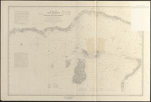
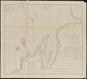
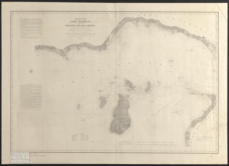
North end of Lake Michigan including the Beaver Island group
Item Information
- Title:
- North end of Lake Michigan including the Beaver Island group
- Issuing body:
- U.S. Lake Survey
- Surveyor:
- Macomb, J. N. (John N.), 1810 or 1811-1889
- Draftsman:
- Mueller, J. U. (John U.)
- Engraver:
- Dougal, William H., 1822-1895
- Surveyor:
- United States. Topographical Bureau
- Name on Item:
-
from trigonometrical surveys under the direction of the Topographical Bureau of the War Department in obedience to acts of Congress requiring the survey of the northern and northwestern lakes under the orders of Captain J.N. Macomb Topographical Engineers in 1854 & 1855 ; reduced drawing by J.U. Müller assistant U.S.L.S. ; engraved by W.H. Dougal
- Date:
-
[1857]
- Format:
-
Maps/Atlases
- Genre:
-
Nautical charts
- Location:
-
Boston Public Library
Norman B. Leventhal Map & Education Center - Collection (local):
-
Norman B. Leventhal Map & Education Center Collection
- Subjects:
-
Michigan, Lake--Maps
Beaver Islands (Mich.)--Maps
Nautical charts--Michigan, Lake
- Places:
-
Michigan, Lake
MichiganCharlevoix (county)Beaver Island (island)
- Extent:
- 1 map ; 59 x 87 cm
- Terms of Use:
-
No known copyright restrictions.
No known restrictions on use.
- Publisher:
-
[Washington, D.C.] :
Survey of the Lakes
- Scale:
-
Scale 1:120,000
- Language:
-
English
- Notes:
-
Relief shown by hachures. Depths shown by soundings and isolines.
Includes note, sailing directions, magnetic observations, table showing variations in stage of water and light houses.
Includes seal with "Survey of the Lakes 1857."
- Notes (date):
-
This date is inferred.
- Notes (citation):
-
Karpinski, 816
Moore, 1-0239, 1-0241
- Identifier:
-
06_01_017449
- Call #:
-
G3312.M5P53 1857 .U83
- Barcode:
-
39999085959250