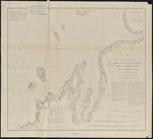
North end of Lake Michigan including Green Bay and the straits of Mackinac

Item Information
- Title:
- North end of Lake Michigan including Green Bay and the straits of Mackinac
- Title (uniform):
-
Survey of the northern and northwestern lakes
- Issuing body:
- U.S. Lake Survey
- Surveyor:
- Macomb, J. N. (John N.), 1810 or 1811-1889
- Surveyor:
- Graham, J. D. (James Duncan), 1799-1865
- Surveyor:
- Raynolds, W. F. (William Franklin), 1820-1894
- Contributor:
- Mueller, J. U.
- Contributor:
- United States. Army. Corps of Topographical Engineers
- Surveyor:
- Meade, George Gordon, 1815-1872
- Engraver:
- Dougal, William H., 1822-1895
- Name on Item:
-
projected from a trigonometrical survey under the orders of Capt. J.N. Macomb Topl. Engrs. in 1851, 52, 53, 54, and 55 ; of Capt. G.G. Meade Topl. Engrs. in 1860 & 61 ; of Col. J.D. Graham Corps of Engrs. in 1862 & 63 ; and of Col. W.F. Raynolds, A.D.C. Maj. of Engrs. in 1864, 65, & 66 ; compiled and reduced for engraving by J.U. Mueller, Asst. U.S.L.S. ; engraved by W.H. Dougal
- Date:
-
[1893]
- Format:
-
Maps/Atlases
- Location:
-
Boston Public Library
Norman B. Leventhal Map & Education Center - Collection (local):
-
Norman B. Leventhal Map & Education Center Collection
- Subjects:
-
Nautical charts--Michigan, Lake
Nautical charts--Green Bay (Wis. and Mich.)
Nautical charts--Michigan--Mackinac, Straits of
Michigan, Lake--Maps
Green Bay (Wis. and Mich.)--Maps
Mackinac, Straits of (Mich.)--Maps
- Places:
-
Michigan, Lake
Green Bay
Straits of Mackinac
- Extent:
- 1 map ; 53 x 76 cm.
- Terms of Use:
-
No known copyright restrictions.
No known restrictions on use.
- Publisher:
-
[Washington, D.C.] :
United States Lake Survey
- Scale:
-
Scale 1:400,000
- Language:
-
English
- Notes:
-
Relief shown by hachures. Depths shown by soundings and isolines.
"Published 1867."
"Aids to navigation corrected to May 14, 1890."
Stamped in purple at bottom: Aids to navigation corrected from information received to Oct 6 1893."
Two notes issued 1894, "Lake Michigan, North end - additional" and "Memorandum," tipped-on in upper left corner.
Includes: Magnetic declinations -- Note -- Dangers -- Sailing directions -- Lighthouses -- Water table.
- Notes (date):
-
This date is inferred.
- Identifier:
-
06_01_015588
- Call #:
-
G3312.M5P5 1893 .U83
- Barcode:
-
39999085937900