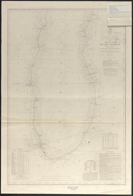
South end of Lake Michigan
Item Information
- Title:
- South end of Lake Michigan
- Issuing body:
- U.S. Lake Survey
- Surveyor:
- Raynolds, W. F. (William Franklin), 1820-1894
- Surveyor:
- Comstock, C. B. (Cyrus Ballou), 1831-1910
- Name on Item:
-
projected from a trigonometrical survey executed under the orders of Lieut. Col. W.F. Raynolds, Corps of Engineers, Brvt. Brig. Genl. U.S.A., in 1866, and of Maj. C.B. Comstock, Corps of Engineers, Brvt. Brig. Genl. in 1870, '71, '72, '73 & '74
- Date:
-
[1894]
- Format:
-
Maps/Atlases
- Genre:
-
Nautical charts
- Location:
-
Boston Public Library
Norman B. Leventhal Map & Education Center - Collection (local):
-
Norman B. Leventhal Map & Education Center Collection
- Subjects:
-
Michigan, Lake--Maps
Nautical charts--Michigan, Lake
- Places:
-
Michigan, Lake
- Extent:
- 1 map ; 91 x 60 cm
- Terms of Use:
-
No known copyright restrictions.
No known restrictions on use.
- Publisher:
-
[Washington, D.C.] :
Bureau of Topographical Engineers
- Scale:
-
Scale 1:400,000
- Language:
-
English
- Notes:
-
Relief shown by hachures. Depths shown by soundings.
Includes list of lighthouses, authorities, note, magnetic variations, dangers, water table and sailing directions.
"Survey of the Northern and Northwestern Lakes, made in obedience to Acts of Congress and orders from the headquarters of the Corps of Engineers, War Department."
"Aids to navigation corrected to September 1889."
Stamped in bottom margin: Aids to navigation corrected from information received to Mar 31 1894.
Two notes issued 1894 tipped-on in upper right corner.
- Notes (date):
-
This date is inferred.
- Identifier:
-
06_01_017447
- Call #:
-
G3312.M5P53 1894 .U83
- Barcode:
-
39999085959235