Toggle navigation
LMEC Home
Exhibitions
Georeferencing
Tools for Teachers
Collections
My Favorites
Sign Up / Log In
Search
Search the map portal
Map Collection
Map Collection
Map Sets
Search
Search
Search for
Search In
All Fields
Creator
Title
Subject
Place
Search All Digital Collections
Advanced Search
987 Results
My Search
Start Over
More Like
commonwealth-oai:v405x789b
Remove constraint More Like: commonwealth-oai:v405x789b
Filter your Search
Place
North and Central America
959
United States
698
Canada
206
New York
194
Quebec
111
Rhode Island
83
Massachusetts
80
Pennsylvania
61
more
Place
»
Topic
United States--History--Revolution, 1775-1783--Maps
330
United States--History--French and Indian War, 1754-1763--Maps
149
Rhode Island--Maps
50
Saint Lawrence River--Maps
43
Massachusetts--Maps
40
Newport (R.I.)--Maps
28
Connecticut--Maps
26
New York (State)--Maps
25
more
Topic
»
Date
Date range begin
–
Date range end
Current results range from
1700
to
1981
View distribution
Creator
Rocque, Mary Ann
29
Holland, Samuel, 1728-1801
25
Jefferys, Thomas, -1771
25
Montrésor, John, 1736-1799
25
Bellin, Jacques Nicolas, 1703-1772
24
Clinton, Henry, Sir, 1738?-1795
19
Robert Sayer and John Bennett (Firm)
16
Hills, John, active 1777-1819
13
more
Creator
»
Format
Maps/Atlases
971
Drawings/Illustrations
11
Documents
5
Manuscripts
4
Objects/Artifacts
1
Prints
1
Georeferenced
Yes
17
No
970
Collection
American Revolutionary War-Era Maps
934
William L. Clements Library Collection
909
Norman B. Leventhal Map & Education Center Collection
56
Boston and New England Maps
43
Maps from AAS
9
David Judkins Weaver Papers
4
Newberry Library Collection
3
Urban Maps
3
more
Collection
»
Available to use
No known restrictions
57
Creative Commons license
5
Search Constraints
Sort by relevance
relevance
title
date (asc)
date (desc)
Number of results to display per page
20 per page
10
per page
20
per page
50
per page
100
per page
View results as:
grid view
map view
Search Results
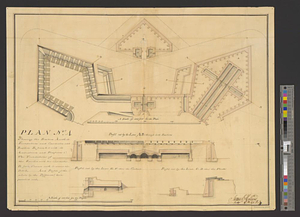
741.
Plan no. 4 shewing the bastion A with its foundations and casemates and bastion B finish'd with its ambrazures and platforms C...
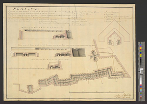
742.
Plan (no. 5) shewing the half bastion C with its foundations and the rampart towards the river side, as far as the loop-hole...
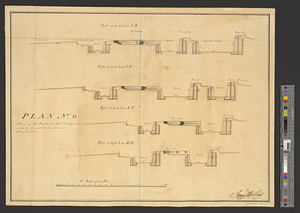
743.
Plan no. 6 shewing the profils cut thro' the different works by the yellow lines seen on plan no. 3
744.
Plan of a city block in Wilmington, Delaware : for Mr Fredrick Wirt 1772
745.
A plan of a rout from Fort Pownall on the river Penobscot in New England to Quebec and from Quebec to Fort Pownall : taken by...
746.
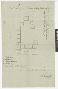
Plan of a settlement call'd Dunlaps Station
747.
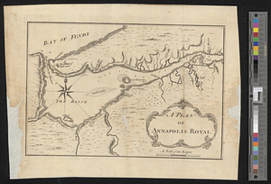
A plan of Annapolis Royal
748.
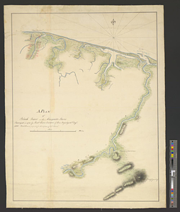
A plan of Black River on the Mosquito shore : surveyed in 1779
749.
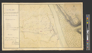
A plan of Cascasquias with the design of an enceinte
750.
A plan of Croft-town : an encampment intended by Major McKenzie for the troops at Mobile during the unhealthy season
751.
Plan of Damons land
752.
Plan of Dean Danl Greens farm in Reading
753.
Plan of Detroit with its environs
754.
Plan of Elizbth Town
755.
Plan of fifty different tracts of land, (of 1000 acres each) containing in the whole 50,000 acres, situate on the waters of...
756.
Plan of Fort [Brewerton] at the west end of Onnide Lake
757.
Plan of Fort Defiance, erected at the confluence of the Miami & Au Glaise rivers in August, 1794
758.
Plan of Fort Edward situated lat. 43 lon. 72 30'
759.
Plan of Fort [Franklin] on French Creek : built by a detachment of the 1st U.S. Regt., 1787
760.
Plan of Fort Frederick at Albany
‹ Prev
Next ›
1
2
…
34
35
36
37
38
39
40
41
42
…
49
50


![Plan of Fort [Brewerton] at the west end of Onnide Lake](https://bpldcassets.blob.core.windows.net/derivatives/metadata/commonwealth-oai:639615613/image_thumbnail_300.jpg)

![Plan of Fort [Franklin] on French Creek](https://bpldcassets.blob.core.windows.net/derivatives/metadata/commonwealth-oai:5x21zf368/image_thumbnail_300.jpg)
