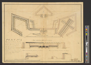
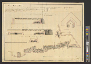
Plan (no. 5) shewing the half bastion C with its foundations and the rampart towards the river side, as far as the loop-hole wall beginning at E in plan (no. 3) with it's casemates and profils cut by the yellow lines thro' the work
This map is also available in American Revolutionary Geographies Online (ARGO), a collections portal especially built for material relating to the American Revolutionary War Era. Visit ARGO to learn more about this item and explore the historical geography of North America in the late eighteenth century.
Item Information
- Title:
- Plan (no. 5) shewing the half bastion C with its foundations and the rampart towards the river side, as far as the loop-hole wall beginning at E in plan (no. 3) with it's casemates and profils cut by the yellow lines thro' the work
- Title (alt.):
-
Profil cut by the line A.B. thro' the half bastion C
Profil cut by the line D.E. thro' the rampart towards the river side and the 2 small magazines & sally gate
Profil cut by the line F.G. thro' the officers kitchen
- Creator:
- Holland, Samuel, 1728-1801
- Date:
-
[1762]
- Format:
-
Maps/Atlases
- Genre:
-
Manuscript maps
- Location:
- William L. Clements Library
- Collection (local):
-
William L. Clements Library Collection
- Subjects:
-
Québec Citadel (Quebec)--Maps
Québec (Québec)--Maps
- Places:
-
CanadaQuebec (province)Québec
- Extent:
- 1 ms. map : col. ; 36.3 x 49 cm
- Terms of Use:
-
The University of Michigan Library provides access to these materials for educational and research purposes. These materials may be under copyright. If you decide to use any of these materials, you are responsible for making your own legal assessment and securing any necessary permission. If you have questions about the collection, please contact the William L. Clements Library.
Contact host institution for more information.
- Scale:
-
Scale 1:600 for the plan and 1:300 for the profiles.
- Language:
-
English
- Catalog Record:
-
Catalog record
- Notes:
-
From Shelburne Papers (Clements Library).
Signed: Samuel Holland capt. of the 60 R.
Fifth of 6 numbered plans for Québec citadel project.
Highly detailed plan and 3 sections of part of the fortifications.
See Governor James Murray's report on the government of Québec (Shelburne Papers (Clements Library), vol. 64, pp. 22-28) dated 5th June 1762.
- Notes (date):
-
This date is inferred.
- Identifier:
-
8211
- Barcode:
-
B1937655