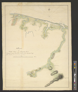
A plan of Black River on the Mosquito shore : surveyed in 1779
This map is also available in American Revolutionary Geographies Online (ARGO), a collections portal especially built for material relating to the American Revolutionary War Era. Visit ARGO to learn more about this item and explore the historical geography of North America in the late eighteenth century.
Item Information
- Title:
- A plan of Black River on the Mosquito shore : surveyed in 1779
- Creator:
- Carden, Hans
- Name on Item:
-
by Lieutt Hans Carden of his majesty's 60th Regt.
- Date:
-
[1779]
- Format:
-
Maps/Atlases
- Genre:
-
Manuscript maps
- Location:
- William L. Clements Library
- Collection (local):
-
William L. Clements Library Collection
- Subjects:
-
Honduras--Maps
- Places:
-
Honduras
- Extent:
- 1 ms. map : col. ; 66.2 x 49.2 cm.
- Terms of Use:
-
The University of Michigan Library provides access to these materials for educational and research purposes. These materials may be under copyright. If you decide to use any of these materials, you are responsible for making your own legal assessment and securing any necessary permission. If you have questions about the collection, please contact the William L. Clements Library.
Contact host institution for more information.
- Scale:
-
Scale 1:32,000.
- Language:
-
English
- Catalog Record:
-
Catalog record
- Notes:
-
Finished, colored, topographical map showing the Black or Negro River and parts of several watercourses immediately to the west.
Houses and agricultural areas distinguished by color.
- Notes (date):
-
This date is inferred.
- Identifier:
-
8390
- Barcode:
-
B2025151
![Map of the coast of Hunduras [sic] from the bay of Truxillo to the river Dulcee also the interieur part of that country, from the mouth of the river Roman to the city of Comayagua and their principle mines](https://bpldcassets.blob.core.windows.net/derivatives/metadata/commonwealth-oai:rj434386k/image_thumbnail_300.jpg)

