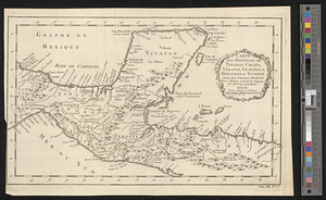
Carte des provinces de Tabasco, Chiapa, Verapaz, Guatimala, Honduras et Yucatan situées dans l'Amérique Meridionale : pour l'histoire générale des voyages
This map is also available in American Revolutionary Geographies Online (ARGO), a collections portal especially built for material relating to the American Revolutionary War Era. Visit ARGO to learn more about this item and explore the historical geography of North America in the late eighteenth century.
Item Information
- Title:
- Carte des provinces de Tabasco, Chiapa, Verapaz, Guatimala, Honduras et Yucatan situées dans l'Amérique Meridionale : pour l'histoire générale des voyages
- Creator:
- Bellin, Jacques Nicolas, 1703-1772
- Name on Item:
-
par M.B. Ingr. de la Marine
- Date:
-
[1754]
- Format:
-
Maps/Atlases
- Location:
- William L. Clements Library
- Collection (local):
-
William L. Clements Library Collection
- Subjects:
-
Mexico--Maps
Guatemala--Maps
Honduras--Maps
El Salvador--Maps
- Places:
-
Mexico
Guatemala
Honduras
El Salvador
- Extent:
- 1 map ; 20.7 x 34 cm
- Terms of Use:
-
The University of Michigan Library provides access to these materials for educational and research purposes. These materials may be under copyright. If you decide to use any of these materials, you are responsible for making your own legal assessment and securing any necessary permission. If you have questions about the collection, please contact the William L. Clements Library.
Contact host institution for more information.
- Place of origin:
-
[Paris]
- Scale:
-
Scale [ca. 1:5,300,000].
- Language:
-
French
- Catalog Record:
-
Catalog record
- Notes:
-
Below neat line at lower right: Tom. XII No. 6.
- Notes (date):
-
This date is inferred.
- Identifier:
-
5514
- Barcode:
-
B1936476
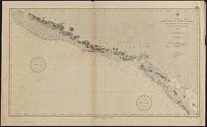
![Map of the coast of Hunduras [sic] from the bay of Truxillo to the river Dulcee also the interieur part of that country, from the mouth of the river Roman to the city of Comayagua and their principle mines](https://bpldcassets.blob.core.windows.net/derivatives/metadata/commonwealth-oai:rj434386k/image_thumbnail_300.jpg)