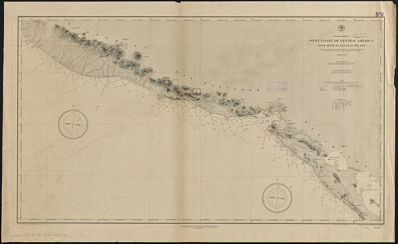
North America, west coast of Central America, Ocos River to San Juan del Sur
Item Information
- Title:
- North America, west coast of Central America, Ocos River to San Juan del Sur
- Issuing body:
- United States. Hydrographic Office
- Draftsman:
- Franke, M. (Max)
- Engraver:
- Dougal, William H., 1822-1895
- Engraver:
- Klakring, C. T. (Charles T.)
- Name on Item:
-
surveyed by the officers of the U.S.S. Tuscarora in 1880, Comdr. J.W. Philip, U.S.N. comdg. and the officers of the U.S.S. Ranger in 1884, Comdr. C.E. Clark, U.S.N. comdg. ; drawn by Max Franke ; engraved by W.H. Dougal and C.T. Klakring
- Date:
-
[1889]
- Format:
-
Maps/Atlases
- Genre:
-
Nautical charts
- Location:
-
Boston Public Library
Norman B. Leventhal Map & Education Center - Collection (local):
-
Norman B. Leventhal Map & Education Center Collection
- Subjects:
-
Central America--Maps
El Salvador--Maps
Guatemala--Maps
Nicaragua--Maps
Coasts--Central America--Maps
Coasts--El Salvador--Maps
Coasts--Guatemala--Maps
Coasts--Nicaragua--Maps
Nautical charts--Central America
Nautical charts--El Salvador
Nautical charts--Guatemala
Nautical charts--Nicaragua
- Places:
-
El Salvador
Guatemala
Nicaragua
- Extent:
- 1 map : hand colored ; 59 x 106 cm
- Terms of Use:
-
No known copyright restrictions.
No known restrictions on use.
- Publisher:
-
Washington, D.C. :
Hydrographic Office
- Edition:
- Edition of May 1889
- Scale:
-
Scale approximately 1:730,000
- Language:
-
English
- Notes:
-
Relief shown by hachures and spot heights. Depths shown by soundings and isolines.
Includes secondary meridians, harbor and special charts, lights and abbreviations.
- Notes (date):
-
This date is inferred.
- Identifier:
-
06_01_015615
- Call #:
-
G9096.P5 svar .U55 no. 931
- Barcode:
-
39999085938908