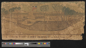
Plan of Fort [Franklin] on French Creek : built by a detachment of the 1st U.S. Regt., 1787
![Plan of Fort [Franklin] on French Creek](https://bpldcassets.blob.core.windows.net/derivatives/metadata/commonwealth-oai:5x21zf368/image_thumbnail_300.jpg)
This map is also available in American Revolutionary Geographies Online (ARGO), a collections portal especially built for material relating to the American Revolutionary War Era. Visit ARGO to learn more about this item and explore the historical geography of North America in the late eighteenth century.
Item Information
- Title:
- Plan of Fort [Franklin] on French Creek : built by a detachment of the 1st U.S. Regt., 1787
- Creator:
- Heart, Jonathan, 1748-1791
- Date:
-
1787
- Format:
-
Maps/Atlases
- Genre:
-
Manuscript maps
- Location:
- William L. Clements Library
- Collection (local):
-
William L. Clements Library Collection
- Subjects:
-
Fort Franklin (Franklin, Pa.)--Maps
- Places:
-
PennsylvaniaVenango (county)Franklin
- Extent:
- 1 ms. map ; 22.7 x 36.3 cm.
- Terms of Use:
-
The University of Michigan Library provides access to these materials for educational and research purposes. These materials may be under copyright. If you decide to use any of these materials, you are responsible for making your own legal assessment and securing any necessary permission. If you have questions about the collection, please contact the William L. Clements Library.
Contact host institution for more information.
- Scale:
-
Scale 1:480.
- Language:
-
English
- Catalog Record:
-
Catalog record
- Notes:
-
Finished, topographical, pen and ink map showing the ground plan of the fort and its immediately adjacent area.
See Heart to Harmar, June 1, 1787, Harmar Papers (Clements Library).
Map was accompanied by a three-page explanation describing this map and two of Heart's plans of Fort Franklin and including a key to the 34 numbered references on this plan.
The explanation is filed with: Map of the country adjacent to Fort [Franklin]...
Space left in title for name of the fort pending a decision by General Harmar.
- Identifier:
-
5657
- Barcode:
-
B2995290
![An east view of Fort [Franklin] on French Creek](https://bpldcassets.blob.core.windows.net/derivatives/metadata/commonwealth-oai:dj5314216/image_thumbnail_300.jpg)
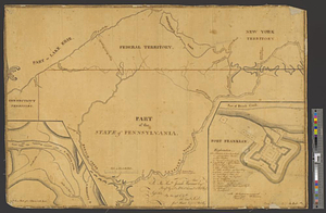
![Map of the country adjacent to Fort [Franklin] on French Creek](https://bpldcassets.blob.core.windows.net/derivatives/metadata/commonwealth-oai:2v240r691/image_thumbnail_300.jpg)