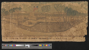
A north view of Fort Franklin on French Creek
This map is also available in American Revolutionary Geographies Online (ARGO), a collections portal especially built for material relating to the American Revolutionary War Era. Visit ARGO to learn more about this item and explore the historical geography of North America in the late eighteenth century.
Item Information
- Title:
- A north view of Fort Franklin on French Creek
- Creator:
- Heart, Jonathan, 1748-1791
- Name on Item:
-
by Jona[than] Heart capt. 1st U.S. Reg.
- Date:
-
[1788]
- Format:
-
Drawings/Illustrations
- Location:
- William L. Clements Library
- Collection (local):
-
William L. Clements Library Collection
- Subjects:
-
Flags--United States--Pictorial works
Fort Franklin (Franklin, Pa.)--Maps
- Places:
-
PennsylvaniaVenango (county)Franklin
- Extent:
- 1 ms. view : col. ; 19 x41.2 cm.
- Terms of Use:
-
The University of Michigan Library provides access to these materials for educational and research purposes. These materials may be under copyright. If you decide to use any of these materials, you are responsible for making your own legal assessment and securing any necessary permission. If you have questions about the collection, please contact the William L. Clements Library.
Contact host institution for more information.
- Scale:
-
Scale indeterminate.
- Language:
-
English
- Catalog Record:
-
Catalog record
- Notes:
-
Finished, colored drawing showing the completed fort and its immediate surroundings.
The post was named Fort Franklin in December 1787.
This view was probably enclosed in Heart to Harmar of February 25, 1788 in the Harmar Papers (Clements Library).
American flag shown in considerable detail.
- Notes (date):
-
This date is inferred.
- Identifier:
-
5663
- Barcode:
-
B2996301
![An east view of Fort [Franklin] on French Creek](https://bpldcassets.blob.core.windows.net/derivatives/metadata/commonwealth-oai:dj5314216/image_thumbnail_300.jpg)
![Map of the country adjacent to Fort [Franklin] on French Creek](https://bpldcassets.blob.core.windows.net/derivatives/metadata/commonwealth-oai:2v240r691/image_thumbnail_300.jpg)