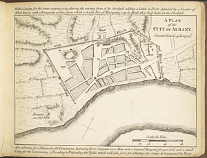
Plan of Fort Frederick at Albany

This map is also available in American Revolutionary Geographies Online (ARGO), a collections portal especially built for material relating to the American Revolutionary War Era. Visit ARGO to learn more about this item and explore the historical geography of North America in the late eighteenth century.
Item Information
- Title:
- Plan of Fort Frederick at Albany
- Title (alt.):
-
Section thro CD
View from the south-east side of the fort
- Contributor:
- Rocque, Mary Ann
- Date:
-
[1763]
- Format:
-
Maps/Atlases
- Location:
- William L. Clements Library
- Collection (local):
-
William L. Clements Library Collection
- Subjects:
-
Fort Frederick (Albany, N.Y.)--Pictorial works
Fort Frederick (Albany, N.Y.)--Maps
Albany (N.Y.)--Maps
United States--History--French and Indian War, 1754-1763--Maps
- Places:
-
New YorkAlbany (county)Albany
- Extent:
- 1 map ; 12.9 x 16.8 cm.
- Terms of Use:
-
The University of Michigan Library provides access to these materials for educational and research purposes. These materials may be under copyright. If you decide to use any of these materials, you are responsible for making your own legal assessment and securing any necessary permission. If you have questions about the collection, please contact the William L. Clements Library.
Contact host institution for more information.
- Publisher:
-
[London] :
[M.A. Rocque]
- Scale:
-
Scale indeterminate.
- Language:
-
English
- Catalog Record:
-
Catalog record
- Notes:
-
In: Rocque, Mary Ann. A set of plans and forts ..., 1763, no. 8.
Major buildings identified.
Insets show elevation and section of fort.
- Notes (date):
-
This date is inferred.
- Identifier:
-
965
- Barcode:
-
B1937210