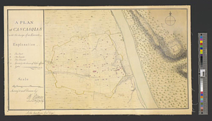
A plan of Cascasquias with the design of an enceinte
This map is also available in American Revolutionary Geographies Online (ARGO), a collections portal especially built for material relating to the American Revolutionary War Era. Visit ARGO to learn more about this item and explore the historical geography of North America in the late eighteenth century.
Item Information
- Title:
- A plan of Cascasquias with the design of an enceinte
- Creator:
- Pittman, Philip, active 1760-1770
- Name on Item:
-
survey'd and drawn by Ph: Pittman, lieut. 15th Regt. asst. engr.
- Date:
-
[1766]
- Format:
-
Maps/Atlases
- Genre:
-
Manuscript maps
- Location:
- William L. Clements Library
- Collection (local):
-
William L. Clements Library Collection
- Subjects:
-
Kaskaskia (Ill.)--Maps
- Places:
-
IllinoisRandolph (county)Kaskaskia
- Extent:
- 1 ms. map : col. ; 29.5 x 50.2 cm.
- Terms of Use:
-
The University of Michigan Library provides access to these materials for educational and research purposes. These materials may be under copyright. If you decide to use any of these materials, you are responsible for making your own legal assessment and securing any necessary permission. If you have questions about the collection, please contact the William L. Clements Library.
Contact host institution for more information.
- Scale:
-
Scale 1:4,800.
- Language:
-
English
- Catalog Record:
-
Catalog record
- Notes:
-
Finished, colored, topographical map showing the fort and village of Kaskaskia with a short explanation identifying important structures.
Enclosed in Pittman to Gage from Fort Chartres, November 20, 1766.
Below neat line is written: To his excellency Genl Gage.
Pittman also wrote a short "Description of Cascasquias," which was enclosed in his letter to Gage from Fort Cavendish on February 24, 1766.
- Notes (date):
-
This date is inferred.
- Identifier:
-
622
- Barcode:
-
B2291631