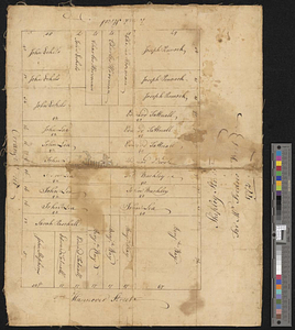
Plan of a city block in Wilmington, Delaware : for Mr Fredrick Wirt 1772
This map is also available in American Revolutionary Geographies Online (ARGO), a collections portal especially built for material relating to the American Revolutionary War Era. Visit ARGO to learn more about this item and explore the historical geography of North America in the late eighteenth century.
Item Information
- Title:
- Plan of a city block in Wilmington, Delaware : for Mr Fredrick Wirt 1772
- Date:
-
1772
- Format:
-
Maps/Atlases
- Genre:
-
Manuscript maps
- Location:
- William L. Clements Library
- Collection (local):
-
William L. Clements Library Collection
- Subjects:
-
Real property--Delaware--Wilmington--Maps
Wilmington (Del.)--Maps
Wirt, Fredrick
- Places:
-
DelawareNew Castle (county)Wilmington
- Extent:
- 1 ms. map ; 33 x 42 cm
- Terms of Use:
-
The University of Michigan Library provides access to these materials for educational and research purposes. These materials may be under copyright. If you decide to use any of these materials, you are responsible for making your own legal assessment and securing any necessary permission. If you have questions about the collection, please contact the William L. Clements Library.
Contact host institution for more information.
- Scale:
-
Scale ca. 1:240.
- Language:
-
English
- Catalog Record:
-
Catalog record
- Notes:
-
Pen and ink plat of lots in the block bounded by Shipley, Hannover, Orange, and Broad streets, identifying owners by name.
Map backed with coarse linen.
- Identifier:
-
5581
- Barcode:
-
B1938992