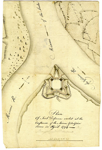
Plan of Fort Defiance, erected at the confluence of the Miami & Au Glaise rivers in August, 1794
This map is also available in American Revolutionary Geographies Online (ARGO), a collections portal especially built for material relating to the American Revolutionary War Era. Visit ARGO to learn more about this item and explore the historical geography of North America in the late eighteenth century.
Item Information
- Title:
- Plan of Fort Defiance, erected at the confluence of the Miami & Au Glaise rivers in August, 1794
- Date:
-
[1794]
- Format:
-
Maps/Atlases
- Genre:
-
Manuscript maps
- Location:
- William L. Clements Library
- Collection (local):
-
William L. Clements Library Collection
- Subjects:
-
Fort Defiance (Defiance, Ohio)--Maps
- Places:
-
OhioDefiance (county)Defiance
Fort Defiance (historical)
- Extent:
- 1 ms. map : col. ; 22.5 x 32.2 cm
- Terms of Use:
-
The University of Michigan Library provides access to these materials for educational and research purposes. These materials may be under copyright. If you decide to use any of these materials, you are responsible for making your own legal assessment and securing any necessary permission. If you have questions about the collection, please contact the William L. Clements Library.
Contact host institution for more information.
- Scale:
-
Scale [1:1,584].
- Language:
-
English
- Catalog Record:
-
Catalog record
- Notes:
-
Relief shown pictorially and by hachures.
North oriented toward upper left.
Pen, ink and watercolor plan of fort.
- Notes (date):
-
This date is inferred.
- Identifier:
-
193
- Barcode:
-
B6457093


