Toggle navigation
LMEC Home
Exhibitions
Georeferencing
Tools for Teachers
Collections
My Favorites
Sign Up / Log In
Search
Search the map portal
Map Collection
Map Collection
Map Sets
Search
Search
Search for
Search In
All Fields
Creator
Title
Subject
Place
Search All Digital Collections
Advanced Search
924 Results
My Search
Start Over
More Like
commonwealth-oai:j3864599s
Remove constraint More Like: commonwealth-oai:j3864599s
Filter your Search
Place
North and Central America
894
United States
636
Canada
209
New York
193
Quebec
112
Pennsylvania
60
New Jersey
54
Nova Scotia
48
more
Place
»
Topic
United States--History--Revolution, 1775-1783--Maps
305
United States--History--French and Indian War, 1754-1763--Maps
162
Saint Lawrence River--Maps
43
Newport (R.I.)--Maps
27
New York (State)--Maps
25
Hudson River (N.Y. and N.J.)--Maps
21
Québec (Québec)--Maps
21
Louisbourg (N.S.)--Maps
20
more
Topic
»
Date
Date range begin
–
Date range end
Current results range from
1700
to
1900
View distribution
Creator
Jefferys, Thomas, -1771
28
Rocque, Mary Ann
28
Holland, Samuel, 1728-1801
25
Montrésor, John, 1736-1799
25
Bellin, Jacques Nicolas, 1703-1772
24
Clinton, Henry, Sir, 1738?-1795
19
Robert Sayer and John Bennett (Firm)
15
Orme, Robert, -1781
14
more
Creator
»
Format
Maps/Atlases
908
Drawings/Illustrations
11
Documents
5
Prints
1
Georeferenced
No
924
Collection
American Revolutionary War-Era Maps
922
William L. Clements Library Collection
909
Norman B. Leventhal Map & Education Center Collection
6
Richard H. Brown Revolutionary War Map Collection at Mount Vernon
4
Maps from AAS
3
MacLean Collection Map Library
1
Maritime Charts and Atlases
1
New-York Historical Society Collection
1
Available to use
No known restrictions
7
Creative Commons license
4
Search Constraints
Sort by relevance
relevance
title
date (asc)
date (desc)
Number of results to display per page
20 per page
10
per page
20
per page
50
per page
100
per page
View results as:
grid view
map view
Search Results
141.
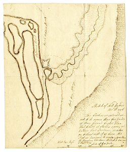
Scetch [sic] of the blockhouse at the east of Oneda Lake
142.
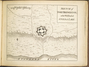
Sketch of Fort Brewerton at the west end of Oneda Lake
143.
Sketch of Fort Edward, Novr. 30th, 1756
144.
Sketch of the country from Fort Du Quesne to Niagara as described by an intelligent Indian who had resided there for a...
145.
Sketch of the country round Tyconderoga
146.
Sketch of the seven dangerous rappids with their true channel : also the appearance the river makes at those places between...
147.
A sketch of the south shore of Lake Ontario between Oswego and Niagara, and from thence up the river to aboute two miles above...
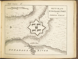
148.
Sketch of the stockade fort, at Oswego Falls
149.
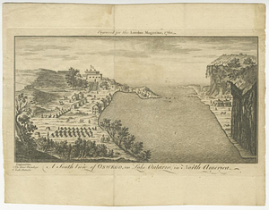
A south view of Oswego, on Lake Ontario, in North America
150.
Southern portion of Lake Megantic and the Dead River : Québec July 25th, 1761
151.
The St. Lawrence River between Coteau des Cedres and Varennes
152.
The St. Lawrence River between Trois Rivières and Grondines Parish
153.
The St. Lawrence River from the Rapids of Richelieu to Cape Torment
154.
A survey of Lake Champlain including Crown Point and St: John's : surveyed by order of his excellency Major Genl: Sir Jeffery...
155.
Town of Three Rivers
156.
Upper New York, Vermont, and Massachusetts
157.
Western shore of Jesus Island and Mille Îles River
158.
Gulf of St. Lawrence, Cape Breton Island, Louisburg Harbor : from British surveys
159.
Karte derer englischen unternehmungen zur zee aus denen franzosischen kusten ... = Carte des entrep: anglo:ises par mer sur les...
160.
A Map of that part of America which was the principal seat of war in 1756
‹ Prev
Next ›
1
2
…
4
5
6
7
8
9
10
11
12
…
46
47
![Scetch [sic] of the blockhouse at the east of Oneda Lake](https://bpldcassets.blob.core.windows.net/derivatives/metadata/commonwealth-oai:zs2626251/image_thumbnail_300.jpg)