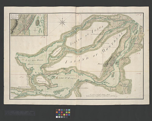
The St. Lawrence River between Coteau des Cedres and Varennes
This map is also available in American Revolutionary Geographies Online (ARGO), a collections portal especially built for material relating to the American Revolutionary War Era. Visit ARGO to learn more about this item and explore the historical geography of North America in the late eighteenth century.
Item Information
- Title:
- The St. Lawrence River between Coteau des Cedres and Varennes
- Title (alt.):
-
Plan of the town of Montreal
- Date:
-
[ca. 1761]
- Format:
-
Maps/Atlases
- Genre:
-
Manuscript maps
- Location:
- William L. Clements Library
- Collection (local):
-
William L. Clements Library Collection
- Subjects:
-
Montréal Island (Québec : Island)--Maps
United States--History--French and Indian War, 1754-1763--Maps
- Places:
-
CanadaQuebec (province)Montréal, Île de (island)
- Extent:
- 1 ms. map : col. ; 48.1 x 70.9 cm.
- Terms of Use:
-
The University of Michigan Library provides access to these materials for educational and research purposes. These materials may be under copyright. If you decide to use any of these materials, you are responsible for making your own legal assessment and securing any necessary permission. If you have questions about the collection, please contact the William L. Clements Library.
Contact host institution for more information.
- Scale:
-
Scale 1:90,000.
- Language:
-
English
- Catalog Record:
-
Catalog record
- Notes:
-
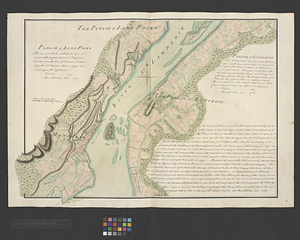
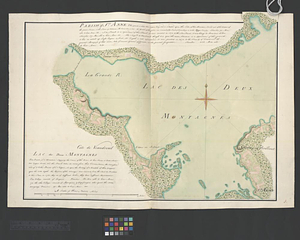
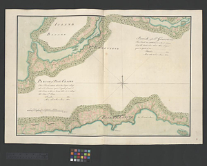
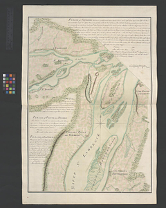
Finished, colored, topographical key map showing the area of the St. Lawrence Valley depicted in 12 individually cataloged maps. The key map includes the bodies of water, islands, villages, and fortifications between Coteau des Cedres and the Island of St. Therese. The map also shows the exact extent of each map and gives the series number of each.
The index map and 12 component maps (sheets 3-14) correspond to title page sheet 1.
Included maps: Plan of the town of Montreal. (sheet 3) -- [Western shore of Jesus Island and Mille Îles River]. (sheet 4) -- Parish of Terbone. (sheet 5) -- Parish of Varrenes. Parish of Pointe aux Trembles. Parish of La Chenais. (sheet 6) -- Parish of St. Anne. Lac des Deux Montagnes. (sheet 7) -- Parish of St. Genevieve. Parish of Pointe Claire. (sheet 8) -- Sault aux Recollets. (sheet 9) -- Parish of Long Point. Parish of Longeuil. [Parish of Montréal]. (sheet 10) -- The Cedres. (sheet 11) -- Parish of Chateau Gay. (sheet 12) - Parish of La Chine. Parish of the Saut of St. Louis. Cocnawaga or St. Louis Indian Castle. (sheet 13) -- Parish of Boucherville. Parish de la Magdelaine. Parish of La Prairie. (sheet 14).
Map is sheet 2 of the Murray Atlas of Canada.
- Identifier:
-
688
- Barcode:
-
B3519700