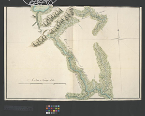
Southern portion of Lake Megantic and the Dead River : Québec July 25th, 1761
This map is also available in American Revolutionary Geographies Online (ARGO), a collections portal especially built for material relating to the American Revolutionary War Era. Visit ARGO to learn more about this item and explore the historical geography of North America in the late eighteenth century.
Item Information
- Title:
- Southern portion of Lake Megantic and the Dead River : Québec July 25th, 1761
- Contributor:
- Shaw, Alexander, Lieutenant
- Creator:
- Montrésor, John, 1736-1799
- Name on Item:
-
by Lieut. John Montresor engr. assisted by Lieut. Shaw of the 2th Battn. of the Royal American Regt.
- Date:
-
July 25, 1761
- Format:
-
Maps/Atlases
- Genre:
-
Manuscript maps
- Location:
- William L. Clements Library
- Collection (local):
-
William L. Clements Library Collection
- Subjects:
-
Dead River (Somerset County and Franklin County, Me.)--Maps
Mégantic, Lake (Québec)--Maps
United States--History--French and Indian War, 1754-1763--Maps
- Places:
-
MaineDead (river)
CanadaQuebec (province)Lac-Mégantic
- Extent:
- 1 ms. map : col. ; 54 x 74 cm.
- Terms of Use:
-
The University of Michigan Library provides access to these materials for educational and research purposes. These materials may be under copyright. If you decide to use any of these materials, you are responsible for making your own legal assessment and securing any necessary permission. If you have questions about the collection, please contact the William L. Clements Library.
Contact host institution for more information.
- Scale:
-
Scale 1:125,000.
- Language:
-
English
- Catalog Record:
-
Catalog record
- Notes:
-
Finished, colored, topographical map of the area showing a section of the Québec-Fort Halifax route taken by Lieutenant John Montresor.
Map is sheet 47 of the Murray Atlas of Canada and sheet 19 of its series.
Map as well as sheets 44-46 and 48 are components of an inset map on key map sheet 16.
- Identifier:
-
701
- Barcode:
-
B3522673


