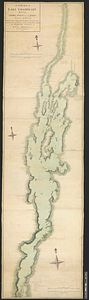
A survey of Lake Champlain including Crown Point and St: John's : surveyed by order of his excellency Major Genl: Sir Jeffery Amherst, knight of the most honorable Order of the Bath, commander in chief of his majesty's forces in North America, &c. &c. &c.
This map is also available in American Revolutionary Geographies Online (ARGO), a collections portal especially built for material relating to the American Revolutionary War Era. Visit ARGO to learn more about this item and explore the historical geography of North America in the late eighteenth century.
Item Information
- Title:
- A survey of Lake Champlain including Crown Point and St: John's : surveyed by order of his excellency Major Genl: Sir Jeffery Amherst, knight of the most honorable Order of the Bath, commander in chief of his majesty's forces in North America, &c. &c. &c.
- Contributor:
- Test, William
- Creator:
- Brasier, William
- Name on Item:
-
by Wm. Brasier draughtsman
- Date:
-
1776
- Format:
-
Maps/Atlases
- Genre:
-
Manuscript maps
- Location:
- William L. Clements Library
- Collection (local):
-
William L. Clements Library Collection
- Subjects:
-
Champlain, Lake--Maps
United States--History--French and Indian War, 1754-1763--Maps
- Places:
-
Champlain, Lake
- Extent:
- 1 ms. map : col. ; 262.5 x 72.4 cm.
- Terms of Use:
-
The University of Michigan Library provides access to these materials for educational and research purposes. These materials may be under copyright. If you decide to use any of these materials, you are responsible for making your own legal assessment and securing any necessary permission. If you have questions about the collection, please contact the William L. Clements Library.
Contact host institution for more information.
- Scale:
-
Scale 1:63,360.
- Language:
-
English
- Catalog Record:
-
Catalog record
- Notes:
-
Inside title border at lower right: William Test delt. 1776.
Finished, colored, topographical map with many notes concerning the various streams emptying into the lake, several of the military engagements fought on its shores, and major topographical features.
Notations include information on where Robert Rogers left his boats on his 1759 raid on Saint Francis.
Two short tables of references identify features of Crown Point and of the attack on Isle aux Noix in 1760.
- Identifier:
-
8354
- Barcode:
-
B2839270


