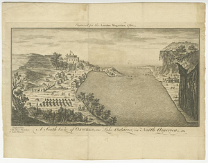
A south view of Oswego, on Lake Ontario, in North America
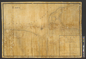
This map is also available in American Revolutionary Geographies Online (ARGO), a collections portal especially built for material relating to the American Revolutionary War Era. Visit ARGO to learn more about this item and explore the historical geography of North America in the late eighteenth century.
Item Information
- Title:
- A south view of Oswego, on Lake Ontario, in North America
- Date:
-
1760
- Format:
-
Prints
- Location:
- William L. Clements Library
- Collection (local):
-
William L. Clements Library Collection
- Subjects:
-
Oswego (N.Y.)--Maps
United States--History--French and Indian War, 1754-1763--Maps
- Places:
-
New YorkOswego (county)Oswego
- Extent:
- 1 view ; 13.3 x 25.5 cm.
- Terms of Use:
-
The University of Michigan Library provides access to these materials for educational and research purposes. These materials may be under copyright. If you decide to use any of these materials, you are responsible for making your own legal assessment and securing any necessary permission. If you have questions about the collection, please contact the William L. Clements Library.
Contact host institution for more information.
- Place of origin:
-
[London]
- Scale:
-
Scale indeterminate.
- Language:
-
English
- Catalog Record:
-
Catalog record
- Notes:
-
Engraved for London magazine.
View of British fort and camps at Oswego as they appeared in 1755.
Copy 2 in: London magazine, vol. 29, May 1760, p. 232.
- Identifier:
-
926
- Barcode:
-
B1936585