Toggle navigation
LMEC Home
Exhibitions
Georeferencing
Tools for Teachers
Collections
My Favorites
Sign Up / Log In
Search
Search the map portal
Map Collection
Map Collection
Map Sets
Search
Search
Search for
Search In
All Fields
Creator
Title
Subject
Place
Search All Digital Collections
Advanced Search
965 Results
My Search
Start Over
More Like
commonwealth-oai:d791xf44c
Remove constraint More Like: commonwealth-oai:d791xf44c
Filter your Search
Place
North and Central America
937
United States
676
Canada
205
New York
193
Quebec
111
Pennsylvania
60
New Jersey
57
Massachusetts
51
more
Place
»
Topic
United States--History--Revolution, 1775-1783--Maps
330
United States--History--French and Indian War, 1754-1763--Maps
149
Saint Lawrence River--Maps
43
Southern States--Maps
29
Newport (R.I.)--Maps
27
New York (State)--Maps
24
Charleston (S.C.)--Maps
23
Hudson River (N.Y. and N.J.)--Maps
21
more
Topic
»
Date
Date range begin
–
Date range end
Current results range from
1700
to
1978
View distribution
Creator
Rocque, Mary Ann
29
Jefferys, Thomas, -1771
26
Holland, Samuel, 1728-1801
25
Montrésor, John, 1736-1799
25
Bellin, Jacques Nicolas, 1703-1772
24
Clinton, Henry, Sir, 1738?-1795
19
Robert Sayer and John Bennett (Firm)
15
Hills, John, active 1777-1819
13
more
Creator
»
Format
Maps/Atlases
949
Drawings/Illustrations
11
Documents
5
Manuscripts
4
Prints
1
Georeferenced
Yes
8
No
957
Collection
American Revolutionary War-Era Maps
937
William L. Clements Library Collection
909
Norman B. Leventhal Map & Education Center Collection
30
Maps from AAS
12
Boston and New England Maps
5
MacLean Collection Map Library
4
Newberry Library Collection
3
Urban Maps
3
more
Collection
»
Available to use
No known restrictions
32
Creative Commons license
5
Search Constraints
Sort by relevance
relevance
title
date (asc)
date (desc)
Number of results to display per page
20 per page
10
per page
20
per page
50
per page
100
per page
View results as:
grid view
map view
Search Results
901.
Sketch of Presque Isle
902.
Sketch of the country from Fort Du Quesne to Niagara as described by an intelligent Indian who had resided there for a...
903.
Sketch of the country round Tyconderoga
904.
A sketch of the entrance from the sea to Apalachy and part of the environs
905.
Sketch of the environs of Charlotteville
906.
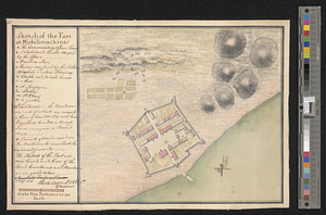
Sketch of the fort at Michilimackinac
907.
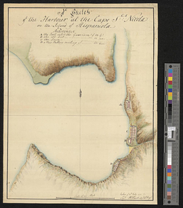
A sketch of the harbour at the Cape Slt: Nicola on the island of Hispaniola
908.
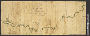
A sketch of the river Missisippi from New Orleans to the Rock of Davion
909.
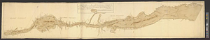
Sketch of the river St. Lawrence from Montreal to the island St. Barnaby on the south side and the islands of Jeremy on the...
910.
Sketch of the river St: Lawrence from Montreal to the island St: Barnaby on the south side, and the islands of Jeremy on the...
911.
Sketch of the roads on the east side of the North River
912.
Sketch of the seven dangerous rappids with their true channel : also the appearance the river makes at those places between...
913.
A sketch of the several Indian roads leading from Fort Pitt to Sioto, Lake Erie &c. : takn. from a draft (made on a tour thro'...
914.
A sketch of the south shore of Lake Ontario between Oswego and Niagara, and from thence up the river to aboute two miles above...
915.
Sketch of the stockade fort, at Oswego Falls
916.
A sketch shewing the situation of 230 acres of land, set apart for his excellency Major General Simcoe, to complete his...
917.
South & North Carolina : an exact map of the boundary line between the provinces of South & North Carolina agreeable to the...
918.
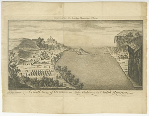
A south view of Oswego, on Lake Ontario, in North America
919.
Southern portion of Lake Megantic and the Dead River : Québec July 25th, 1761
920.
Southwest coast of St. Vincent
‹ Prev
Next ›
1
2
…
42
43
44
45
46
47
48
49