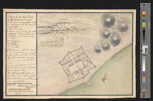
Sketch of the fort at Michilimackinac
This map is also available in American Revolutionary Geographies Online (ARGO), a collections portal especially built for material relating to the American Revolutionary War Era. Visit ARGO to learn more about this item and explore the historical geography of North America in the late eighteenth century.
Item Information
- Title:
- Sketch of the fort at Michilimackinac
- Creator:
- Magra, Perkins
- Date:
-
[1765]
- Format:
-
Maps/Atlases
- Genre:
-
Manuscript maps
- Location:
- William L. Clements Library
- Collection (local):
-
William L. Clements Library Collection
- Subjects:
-
Fort Michilimackinac (Mackinaw City, Mich.)--Maps
- Places:
-
MichiganEmmet (county)Mackinaw City
- Extent:
- 1 ms. map : col. ; 21 x 31.9 cm.
- Terms of Use:
-
The University of Michigan Library provides access to these materials for educational and research purposes. These materials may be under copyright. If you decide to use any of these materials, you are responsible for making your own legal assessment and securing any necessary permission. If you have questions about the collection, please contact the William L. Clements Library.
Contact host institution for more information.
- Scale:
-
Scale ca. 1:720.
- Language:
-
English
- Catalog Record:
-
Catalog record
- Notes:
-
Signed below table of references: Perks Magra lt. 15 Regt.overseer.
Finished, colored, topographical map showing details of the mainland, the fort, and immediately surrounding countryside.
Table of references identifies major features of fort.
Date derived from correspondence in Gage Papers (Clements Library) for summer and fall of 1765.
- Notes (date):
-
This date is inferred.
- Identifier:
-
888
- Barcode:
-
B1939961


