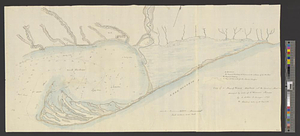
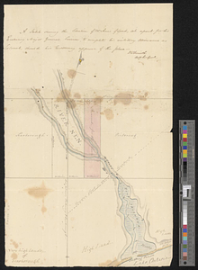
A sketch shewing the situation of 230 acres of land, set apart for his excellency Major General Simcoe, to complete his military allowance as colonel, should his excellency approve of the place
This map is also available in American Revolutionary Geographies Online (ARGO), a collections portal especially built for material relating to the American Revolutionary War Era. Visit ARGO to learn more about this item and explore the historical geography of North America in the late eighteenth century.
Item Information
- Title:
- A sketch shewing the situation of 230 acres of land, set apart for his excellency Major General Simcoe, to complete his military allowance as colonel, should his excellency approve of the place
- Creator:
- Smith, David William, Sir, 1764-1837
- Name on Item:
-
DW Smith actg sur gen.
- Date:
-
[1790–1799]
- Format:
-
Maps/Atlases
- Genre:
-
Manuscript maps
- Location:
- William L. Clements Library
- Collection (local):
-
William L. Clements Library Collection
- Subjects:
-
Real property--Ontario--Pickering--Maps
Pickering (Ont.)--Maps
Simcoe, John Graves, 1752-1806
- Places:
-
CanadaOntario (province)Pickering
- Extent:
- 1 ms. map : col. ; 43 x 27.7 cm.
- Terms of Use:
-
The University of Michigan Library provides access to these materials for educational and research purposes. These materials may be under copyright. If you decide to use any of these materials, you are responsible for making your own legal assessment and securing any necessary permission. If you have questions about the collection, please contact the William L. Clements Library.
Contact host institution for more information.
- Scale:
-
Scale 20 chains to 1 inch.
- Language:
-
English
- Catalog Record:
-
Catalog record
- Notes:
-
Finished, colored, topographical plat of lands located near the mouth of the River Nen in the town of Pickering.
- Notes (date):
-
This date is inferred.
- Identifier:
-
5672
- Barcode:
-
B2997208