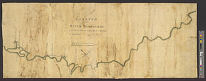
A sketch of the river Missisippi from New Orleans to the Rock of Davion
This map is also available in American Revolutionary Geographies Online (ARGO), a collections portal especially built for material relating to the American Revolutionary War Era. Visit ARGO to learn more about this item and explore the historical geography of North America in the late eighteenth century.
Item Information
- Title:
- A sketch of the river Missisippi from New Orleans to the Rock of Davion
- Contributor:
- Brasier, William
- Creator:
- Pittman, Philip, active 1760-1770
- Name on Item:
-
by Ph: Pittman. Copy W. Brasier
- Date:
-
[1760–1769]
- Format:
-
Maps/Atlases
- Genre:
-
Manuscript maps
- Location:
- William L. Clements Library
- Collection (local):
-
William L. Clements Library Collection
- Subjects:
-
Mississippi River--Maps
Louisiana--Maps
Mississippi--Maps
- Places:
-
Mississippi River
Louisiana
Mississippi
- Extent:
- 1 ms. map : col. ; 38 x 92.6 cm.
- Terms of Use:
-
The University of Michigan Library provides access to these materials for educational and research purposes. These materials may be under copyright. If you decide to use any of these materials, you are responsible for making your own legal assessment and securing any necessary permission. If you have questions about the collection, please contact the William L. Clements Library.
Contact host institution for more information.
- Scale:
-
Scale of leagues.
- Language:
-
English
- Catalog Record:
-
Catalog record
- Notes:
-
Colored strip map of the river from New Orleans to the mouth of the Red River showing a number of Native American settlements and the German settlements north of New Orleans.
At north end of map is indicated the place where an English convoy was attacked on March 20, 1764.
- Notes (date):
-
This date is inferred.
- Identifier:
-
893
- Barcode:
-
B3311258