Toggle navigation
LMEC Home
Exhibitions
Georeferencing
Tools for Teachers
Collections
My Favorites
Sign Up / Log In
Search
Search the map portal
Map Collection
Map Collection
Map Sets
Search
Search
Search for
Search In
All Fields
Creator
Title
Subject
Place
Search All Digital Collections
Advanced Search
14021 Results
Filter your Search
Place
North and Central America
10,683
United States
8,692
Massachusetts
2,808
Suffolk (county)
1,682
Boston
1,638
Europe
1,420
Canada
1,009
New York
674
more
Place
»
Topic
Boston (Mass.)--Maps
748
City planning--Massachusetts--Boston--Maps
418
United States--History--Revolution, 1775-1783--Maps
331
United States--Maps
328
Real property--Massachusetts--Boston--Maps
254
Urban renewal--Massachusetts--Boston--Maps
254
North America--Maps--Early works to 1800
240
Massachusetts--Maps
234
more
Topic
»
Date
Date range begin
–
Date range end
Current results range from
1482
to
2023
View distribution
Creator
United States. Hydrographic Office
597
Boston Redevelopment Authority
404
Des Barres, Joseph F. W. (Joseph Frederick Wallet), 1722-1824
247
Jefferys, Thomas, -1771
172
Royal United Services Institute for Defence and Security Studies
160
George, III, King of Great Britain, 1738-1820
152
George, IV, King of Great Britain, 1762-1830
151
O.H. Bailey & Co
148
more
Creator
»
Format
Maps/Atlases
13,839
Manuscripts
985
Prints
102
Books
49
Drawings/Illustrations
44
Photographs
15
Objects/Artifacts
13
Documents
7
more
Format
»
Georeferenced
Yes
979
No
13,042
Collection
Norman B. Leventhal Map & Education Center Collection
9,110
American Revolutionary War-Era Maps
3,627
Boston and New England Maps
2,921
Urban Maps
2,480
Maritime Charts and Atlases
1,169
William L. Clements Library Collection
910
Library of Congress Collection
618
Boston Redevelopment Authority Collection
475
more
Collection
»
Available to use
No known restrictions
10,268
Creative Commons license
1,678
Search Constraints
Sort by relevance
relevance
title
date (asc)
date (desc)
Number of results to display per page
20 per page
10
per page
20
per page
50
per page
100
per page
View results as:
grid view
map view
Search Results
901.
Austria archiducatus
902.
Austria Hungary
903.
Austria Hungary
904.
Austriae archiducatus pars inferior in omnes ejusdem quadrantes ditiones accuratissime et distincte delineata
905.
Austriae archiducatus pars superior in omnes ejusdem quadrantes ditiones accuratissime et distincte delineata
906.
Austria-Hungary
907.
The Austrian French and Dutch Netherlands, from the best authorities
908.
Austria-Russian operations, European war
909.
An authentic plan of the River St. Laurence, from Sillery to the Fall of Montmerenci : with the operations of the Siege of...
910.
An authentic plan of the River St. Laurence, from Sillery to the Fall of Montmorenci : with the operations of the Siege of...
911.
An authentic plan of the River St. Laurence from Sillery to the fall of Montmorenci, with the operations of the siege of Quebec...
912.
An authentic plan of the town and harbour of Cap-François in the isle of St. Domingo
913.
Automobile map of Massachusetts : central section
914.
Automobile map of New England showing the ideal tour
915.
Aviation map of United States : featuring landing fields, improved, unimproved
916.
Ayer, Mass
917.
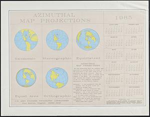
Azimuthal map projections
918.
Azores
919.
Azores, Corvo and Flores
920.
Azores, Corvo and Flores
‹ Prev
Next ›
1
2
…
42
43
44
45
46
47
48
49
50
…
701
702