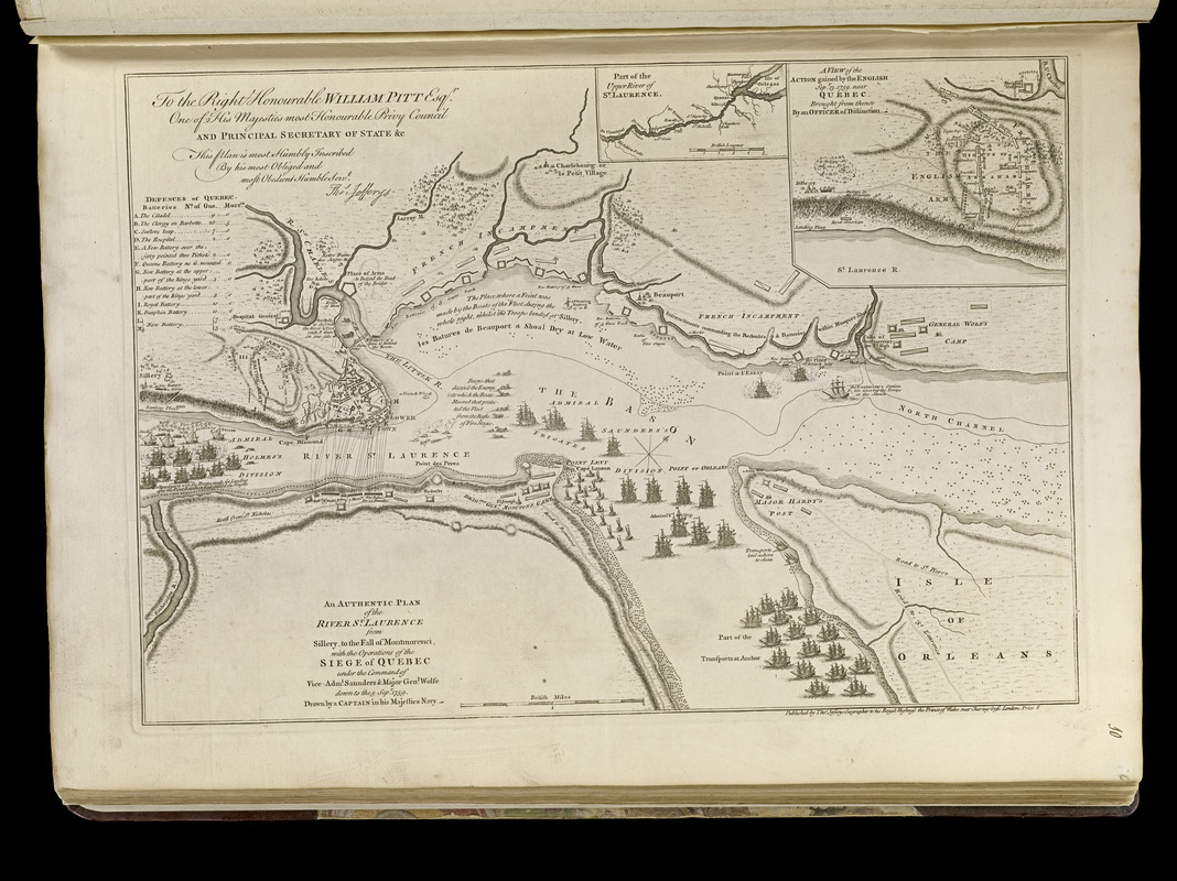
An authentic plan of the River St. Laurence from Sillery to the fall of Montmorenci, with the operations of the siege of Quebec : under the command of Vice-Adml. Saunders & Major Genl. Wolfe down to the 5 Sepr. 1759
Item Information
- Title:
- An authentic plan of the River St. Laurence from Sillery to the fall of Montmorenci, with the operations of the siege of Quebec : under the command of Vice-Adml. Saunders & Major Genl. Wolfe down to the 5 Sepr. 1759
- Creator:
- Jefferys, Thomas, -1771
- Name on Item:
-
drawn by a Captain in his Majesties Navy
- Date:
-
[1768]
- Format:
-
Maps/Atlases
- Location:
-
Boston Public Library
Norman B. Leventhal Map & Education Center - Collection (local):
-
Norman B. Leventhal Map & Education Center Collection
- Subjects:
-
Québec Campaign, Québec, 1759--Maps--Early works to 1800
Québec (Québec)--Maps--Early works to 1800
Saint Lawrence River--Maps--Early works to 1800
- Places:
-
CanadaQuebec (province)Québec
Saint Lawrence River
- Extent:
- 1 map ; 33 x 47 cm.
- Terms of Use:
-
No known copyright restrictions.
No known restrictions on use.
- Publisher:
-
London :
Thos Jefferys
- Scale:
-
Scale [ca. 1:34,800]
- Language:
-
English
- Notes:
-
Oriented with north to the upper right.
Relief shown by hachures.
Insets: Part of the Upper River of St. Laurence -- A view of the action gained by the English Sepr. 13, 1759 near Quebec.
Dedication: To the Right Honourable William Pitt Esqr. one of His Majesties most Honourable Privy Council and Principal Secretary of State & c, this plan is most humbly inscribed by his most obliged and most obedient Humble servt. Thos. Jefferys.
Includes illustrations and references.
Appears in Jefferys' General topography of North America and the West Indies. London: Printed for Robert Sayer, ... and Thomas Jefferys, 1768.
- Notes (date):
-
This date is inferred.
- Notes (citation):
-
List of maps of America, p. 760
Phillips, 1196
- Identifier:
-
4000137_0027r
- Call #:
-
G1105 .J4 1768
- Barcode:
-
30000003253856


