Toggle navigation
LMEC Home
Exhibitions
Georeferencing
Tools for Teachers
Collections
My Favorites
Sign Up / Log In
Search
Search the map portal
Map Collection
Map Collection
Map Sets
Search
Search
Search for
Search In
All Fields
Creator
Title
Subject
Place
Search All Digital Collections
Advanced Search
931 Results
My Search
Start Over
More Like
commonwealth-oai:6d573t27d
Remove constraint More Like: commonwealth-oai:6d573t27d
Filter your Search
Place
North and Central America
904
United States
630
Canada
225
New York
192
Quebec
111
Pennsylvania
60
Nova Scotia
56
New Jersey
54
more
Place
»
Topic
United States--History--Revolution, 1775-1783--Maps
305
United States--History--French and Indian War, 1754-1763--Maps
149
Saint Lawrence River--Maps
43
Newport (R.I.)--Maps
27
New York (State)--Maps
24
Hudson River (N.Y. and N.J.)--Maps
21
Québec (Québec)--Maps
21
Louisbourg (N.S.)--Maps
20
more
Topic
»
Date
Date range begin
–
Date range end
Current results range from
1700
to
1999
View distribution
Creator
Rocque, Mary Ann
29
Bellin, Jacques Nicolas, 1703-1772
25
Holland, Samuel, 1728-1801
25
Montrésor, John, 1736-1799
25
Jefferys, Thomas, -1771
24
Clinton, Henry, Sir, 1738?-1795
19
Robert Sayer and John Bennett (Firm)
16
Hills, John, active 1777-1819
13
more
Creator
»
Format
Maps/Atlases
915
Drawings/Illustrations
11
Documents
5
Prints
1
Georeferenced
No
931
Collection
American Revolutionary War-Era Maps
913
William L. Clements Library Collection
909
Norman B. Leventhal Map & Education Center Collection
18
Maritime Charts and Atlases
4
Boston and New England Maps
2
Applied Geographics, Inc. Records
1
David Judkins Weaver Papers
1
Library and Archives Canada Collection
1
more
Collection
»
Available to use
No known restrictions
18
Creative Commons license
1
Search Constraints
Sort by relevance
relevance
title
date (asc)
date (desc)
Number of results to display per page
20 per page
10
per page
20
per page
50
per page
100
per page
View results as:
grid view
map view
Search Results
21.
McMillan's map of New Brunswick, 1867
22.
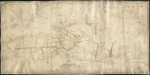
Canada and Nova Scotia
23.
L'Isle de Terre-Neuve, l'Acadie, ou la Nouvelle Ecosse, : l'Isle St. Jean et la partie orientale du Canada
24.
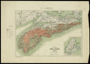
Map of the province of Nova Scotia including Cape Breton Prince Edwards Island and part of New Brunswick
25.
Map of the province of Nova Scotia to illustrate report by E.R. Faribault, B.A. Sc. on the "Gold fields of Nova Scotia"
26.
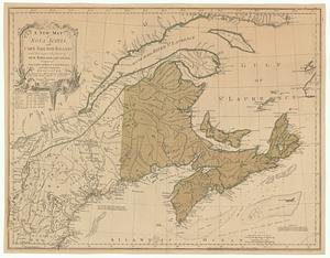
A new map of Nova Scotia, and Cape Breton Island with the adjacent parts of New England and Canada, composed from a great...
27.
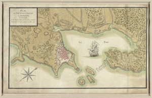
Plan du port et de la ville de Louisbourg en l'Isle Royale, et des attaques faites par les Anglois pendant le siége dépuis le...
28.
S.e. coast of Nova Scotia : from the most recent British surveys
29.
A small map of the sea coast of New England together with the outlines of several of the provinces lying thereon, 1738
30.
15 lots of 440a each in Great Lot no. 4 of Macomb purchase : 6600 acres within 2 miles of the St. Lawrence Turnpike & 1/2 mile...
31.
The above is a connection of the three surveys which I have been able to make on Peters Creek, of yours to gether with John...
32.
An accurate map of Canada, with the adjacent countries; exhibiting the late seat of war between the English & French in those...
33.
An accurate map of New York in North America from a late survey
34.
An accurate map of the British empire in Nth. America as settled by the preliminaries in 1762
35.
An accurate map of the island of St. Christophers, from an actual survey; shewing the parishes, churches; and rivers; also the...
36.
An accurate map of the West Indies : exhibiting not only all the islands possess'd by the English, French, Spaniards & Dutch...
37.
An accurate map of the West Indies, containing the Bahama & Caribbe islands the Great & Little Antilles; with the Leward and...
38.
Action between Genl. St Clairs army & that of the American Indians Novr. 4th 1791 : collected from his public letter
39.
Admiral George Clinton's lands in the "Oblong"
40.
Affaire de Monmouth ce 28me Juin 1778
‹ Prev
Next ›
1
2
3
4
5
6
…
46
47