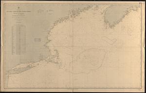
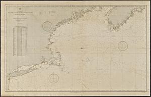
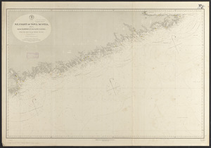
S.e. coast of Nova Scotia : from the most recent British surveys

Item Information
- Title:
- S.e. coast of Nova Scotia : from the most recent British surveys
- Title (alt.):
-
Sheet 1, From Cape Sable to Sambro Id.
Sheet 2, From Sambro Id. to Cape Canso
- Issuing body:
- United States. Hydrographic Office
- Date:
-
1889
- Format:
-
Maps/Atlases
- Location:
-
Boston Public Library
Norman B. Leventhal Map & Education Center - Collection (local):
-
Norman B. Leventhal Map & Education Center Collection
- Subjects:
-
Coasts--Nova Scotia--Maps
Nautical charts--Nova Scotia
Nova Scotia--Maps
- Places:
-
CanadaNova Scotia (province)
- Extent:
- 1 map on 2 sheets : hand colored ; 115 x 153 cm, on sheets 102 x 71 cm.
- Terms of Use:
-
No known copyright restrictions.
No known restrictions on use.
- Publisher:
-
Washington, D.C. :
Hydrographic Office
- Edition:
- Edition of October 1888
- Scale:
-
Scale approximately 1:267,500
- Language:
-
English
- Table of Contents:
-
Sheet I. From Cape Sable to Sambro Id.
Sheet II. From Sambro Id. to Cape Canso.
- Notes:
-
Relief shown by hachures and spot heights. Depths shown by soundings and form lines.
"Cor. (1888-50,)(1889,7."
"Cor. (1889-14."
- Identifier:
-
06_01_015578A
06_01_015578B
- Call #:
-
G3422.C6P5 1889 .U552
- Barcode:
-
39999085938080