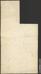
Admiral George Clinton's lands in the "Oblong"

This map is also available in American Revolutionary Geographies Online (ARGO), a collections portal especially built for material relating to the American Revolutionary War Era. Visit ARGO to learn more about this item and explore the historical geography of North America in the late eighteenth century.
Item Information
- Title:
- Admiral George Clinton's lands in the "Oblong"
- Date:
-
[1767]
- Format:
-
Maps/Atlases
- Genre:
-
Manuscript maps
- Location:
- William L. Clements Library
- Collection (local):
-
William L. Clements Library Collection
- Subjects:
-
Real property--New York (State)--Westchester County--Maps
Oblong (N.Y.)--Maps
Westchester County (N.Y.)--Maps
Clinton, George, approximately 1686-1761
Clinton, George, 1739-1812
Clinton, Henry, Sir, 1738?-1795
- Places:
-
New YorkWestchester (county)
- Extent:
- 1 ms. map : col. ; 37.5 x 23 cm
- Terms of Use:
-
The University of Michigan Library provides access to these materials for educational and research purposes. These materials may be under copyright. If you decide to use any of these materials, you are responsible for making your own legal assessment and securing any necessary permission. If you have questions about the collection, please contact the William L. Clements Library.
Contact host institution for more information.
- Scale:
-
Scale [ca. 1:23,040].
- Language:
-
English
- Catalog Record:
-
Catalog record
- Notes:
-
Finished, colored topographical map of George Clinton's holdings.
Endorsed on the back by Sir Henry Clinton: Estate in America of 2000 acres, another of 4,000 in Ulster, to both which Gov. Clinton is my agent, & I suppose will one day render me an honourable acct. of H. Clinton. Nov. 19, 1789.
See Cockburn to Clinton, December 1, 1767.
Clinton Maps 191.
- Notes (date):
-
This date is inferred.
- Identifier:
-
1632
- Barcode:
-
B1936703
![Upper Salem and part of the tounds [sic] joining it for two or three miles distance](https://bpldcassets.blob.core.windows.net/derivatives/metadata/commonwealth-oai:8k71sf77k/image_thumbnail_300.jpg)
