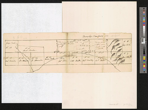
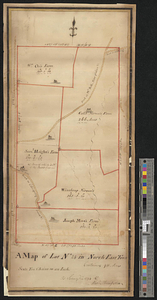
Part of the "Oblong" in modern Putnam County
This map is also available in American Revolutionary Geographies Online (ARGO), a collections portal especially built for material relating to the American Revolutionary War Era. Visit ARGO to learn more about this item and explore the historical geography of North America in the late eighteenth century.
Item Information
- Title:
- Part of the "Oblong" in modern Putnam County
- Contributor:
- Clinton, George, approximately 1686-1761
- Date:
-
1753
- Format:
-
Maps/Atlases
- Genre:
-
Manuscript maps
- Location:
- William L. Clements Library
- Collection (local):
-
William L. Clements Library Collection
- Subjects:
-
Real property--New York (State)--Putnam County--Maps
Oblong (N.Y.)--Maps
Putnam County (N.Y.)--Maps
Clinton, Henry, Sir, 1738?-1795
- Places:
-
New YorkPutnam (county)
- Extent:
- 1 ms. map ; 14.3 x 47 cm
- Terms of Use:
-
The University of Michigan Library provides access to these materials for educational and research purposes. These materials may be under copyright. If you decide to use any of these materials, you are responsible for making your own legal assessment and securing any necessary permission. If you have questions about the collection, please contact the William L. Clements Library.
Contact host institution for more information.
- Scale:
-
Scale [ca. 1:43,200].
- Language:
-
English
- Catalog Record:
-
Catalog record
- Notes:
-
Pen and ink outline map of a few of the holdings in the "Oblong," giving names of owners.
Endorsed on the back by Sir Henry Clinton: My Fathers valuation of Danbury land wrote by himself.
Another endorsement in a different hand: Aprill ye 13 1753.
Clinton Maps 190.
- Identifier:
-
1816
- Barcode:
-
B1936702

![Upper Salem and part of the tounds [sic] joining it for two or three miles distance](https://bpldcassets.blob.core.windows.net/derivatives/metadata/commonwealth-oai:8k71sf77k/image_thumbnail_300.jpg)
