Part of the modern counties of Litchfield and Fairfield, Connecticut, and Westchester and Putnam, New York
This map is also available in American Revolutionary Geographies Online (ARGO), a collections portal especially built for material relating to the American Revolutionary War Era. Visit ARGO to learn more about this item and explore the historical geography of North America in the late eighteenth century.
Item Information
- Title:
- Part of the modern counties of Litchfield and Fairfield, Connecticut, and Westchester and Putnam, New York
- Creator:
- Close, Abraham
- Name on Item:
-
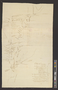
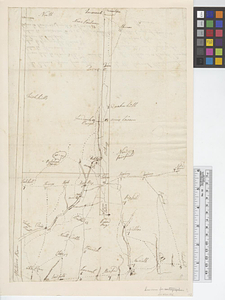
the within is a rough draugh[t] recollected and drawn by Abraham Close lieut. of the Corps of guides & pioneres
- Date:
-
[1770–1779]
- Format:
-
Maps/Atlases
- Genre:
-
Manuscript maps
- Location:
- William L. Clements Library
- Collection (local):
-
William L. Clements Library Collection
- Subjects:
-
Litchfield County (Conn.)--Maps
Fairfield County (Conn.)--Maps
Westchester County (N.Y.)--Maps
Putnam County (N.Y.)--Maps
Oblong (N.Y.)--Maps
United States--History--Revolution, 1775-1783--Maps
- Places:
-
ConnecticutLitchfield (county)
ConnecticutFairfield (county)
New YorkWestchester (county)
New YorkPutnam (county)
- Extent:
- 1 ms. map ; 38 x 24.6 cm.
- Terms of Use:
-
The University of Michigan Library provides access to these materials for educational and research purposes. These materials may be under copyright. If you decide to use any of these materials, you are responsible for making your own legal assessment and securing any necessary permission. If you have questions about the collection, please contact the William L. Clements Library.
Contact host institution for more information.
- Scale:
-
Scale indeterminable.
- Language:
-
English
- Catalog Record:
-
Catalog record
- Notes:
-
Rough, pen and ink drawing showing distances from Salem, New York to neighboring towns and position of the Oblong.
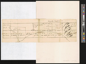
Table of distances given on verso.
Clinton Maps 113.
- Notes (date):
-
This date is inferred.
- Identifier:
-
748
- Barcode:
-
B1936369