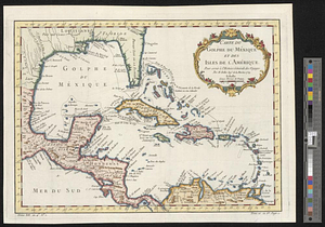
An accurate map of the West Indies : exhibiting not only all the islands possess'd by the English, French, Spaniards & Dutch but also all the towns and settlements on the continent of America adjacent thereto

This map is also available in American Revolutionary Geographies Online (ARGO), a collections portal especially built for material relating to the American Revolutionary War Era. Visit ARGO to learn more about this item and explore the historical geography of North America in the late eighteenth century.
Item Information
- Title:
- An accurate map of the West Indies : exhibiting not only all the islands possess'd by the English, French, Spaniards & Dutch but also all the towns and settlements on the continent of America adjacent thereto
- Contributor:
- Bowen, Emanuel, 1693 or 1694-1767
- Date:
-
[1740]
- Format:
-
Maps/Atlases
- Location:
- William L. Clements Library
- Collection (local):
-
William L. Clements Library Collection
- Subjects:
-
West Indies--Maps
- Places:
-
West Indies
- Extent:
- 1 map ; 30.5 x 39.4 cm.
- Terms of Use:
-
The University of Michigan Library provides access to these materials for educational and research purposes. These materials may be under copyright. If you decide to use any of these materials, you are responsible for making your own legal assessment and securing any necessary permission. If you have questions about the collection, please contact the William L. Clements Library.
Contact host institution for more information.
- Publisher:
-
London :
Printed for E. Cave at St Johns Gate
- Scale:
-
Scale 1:14,000,000.
- Language:
-
English
- Catalog Record:
-
Catalog record
- Notes:
-
Engraved by: Emanl. Bowen.
Removed from Clements copy of Gentleman's magazine, vol. 10 (Jan. 1740), p. 4.
Map of West Indies showing prevailing winds.
Blocks of text provide navigation information.
Below imprint is text advertising Geography reformed; or a new system of general geography.
- Notes (date):
-
This date is inferred.
- Identifier:
-
5487
- Barcode:
-
B3867485