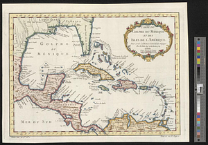
An accurate map of the West Indies, containing the Bahama & Caribbe islands the Great & Little Antilles; with the Leward and Windward Islands & part of the American continent

This map is also available in American Revolutionary Geographies Online (ARGO), a collections portal especially built for material relating to the American Revolutionary War Era. Visit ARGO to learn more about this item and explore the historical geography of North America in the late eighteenth century.
Item Information
- Title:
- An accurate map of the West Indies, containing the Bahama & Caribbe islands the Great & Little Antilles; with the Leward and Windward Islands & part of the American continent
- Creator:
- Bowen, Emanuel, 1693 or 1694-1767
- Name on Item:
-
by E. Bowen geog. to his majy.
- Date:
-
1758
- Format:
-
Maps/Atlases
- Location:
- William L. Clements Library
- Collection (local):
-
William L. Clements Library Collection
- Subjects:
-
West Indies--Maps
- Places:
-
West Indies
- Extent:
- 1 map ; 18.4 x 26 cm
- Terms of Use:
-
The University of Michigan Library provides access to these materials for educational and research purposes. These materials may be under copyright. If you decide to use any of these materials, you are responsible for making your own legal assessment and securing any necessary permission. If you have questions about the collection, please contact the William L. Clements Library.
Contact host institution for more information.
- Publisher:
-
[London] :
For W. Owen at Temple Bar
- Scale:
-
Scale [1:13,000,000].
- Language:
-
English
- Catalog Record:
-
Catalog record
- Notes:
-
Engraved for: General magazine of arts and sciences, philosophical, philological, mathematical, and mechanical.
- Identifier:
-
5541
- Barcode:
-
B1936561