Toggle navigation
LMEC Home
Exhibitions
Georeferencing
Tools for Teachers
Collections
My Favorites
Sign Up / Log In
Search
Search the map portal
Map Collection
Map Collection
Map Sets
Search
Search
Search for
Search In
All Fields
Creator
Title
Subject
Place
Search All Digital Collections
Advanced Search
957 Results
My Search
Start Over
More Like
commonwealth-oai:66832281t
Remove constraint More Like: commonwealth-oai:66832281t
Filter your Search
Place
North and Central America
931
United States
671
Canada
205
New York
192
Quebec
111
Pennsylvania
60
New Jersey
54
South Carolina
50
more
Place
»
Topic
United States--History--Revolution, 1775-1783--Maps
305
United States--History--French and Indian War, 1754-1763--Maps
149
Saint Lawrence River--Maps
43
North Carolina--Maps
30
Newport (R.I.)--Maps
27
New York (State)--Maps
24
Georgia--Maps
23
Hudson River (N.Y. and N.J.)--Maps
21
more
Topic
»
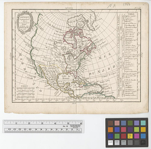
Date
Date range begin
–
Date range end
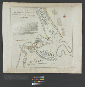
Current results range from
1700
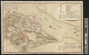
to
1987
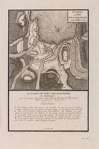
View distribution
Creator
Rocque, Mary Ann
29
Bellin, Jacques Nicolas, 1703-1772
25
Holland, Samuel, 1728-1801
25
Montrésor, John, 1736-1799
25
Jefferys, Thomas, -1771
24
Clinton, Henry, Sir, 1738?-1795
19
Robert Sayer and John Bennett (Firm)
15
Hills, John, active 1777-1819
13
more
Creator
»
Format
Maps/Atlases
941
Drawings/Illustrations
11
Documents
5
Prints
1
Georeferenced
Yes
6
No
951
Collection
American Revolutionary War-Era Maps
921
William L. Clements Library Collection
909
Norman B. Leventhal Map & Education Center Collection
38
Maps from AAS
9
Applied Geographics, Inc. Records
1
MacLean Collection Map Library
1
Available to use
No known restrictions
38
Search Constraints
Sort by relevance
relevance
title
date (asc)
date (desc)
Number of results to display per page
20 per page
10
per page
20
per page
50
per page
100
per page
View results as:
grid view
map view
Search Results
61.
An accurate map of the West Indies : exhibiting not only all the islands possess'd by the English, French, Spaniards & Dutch...
62.
An accurate map of the West Indies, containing the Bahama & Caribbe islands the Great & Little Antilles; with the Leward and...
63.
Action between Genl. St Clairs army & that of the American Indians Novr. 4th 1791 : collected from his public letter
64.
Admiral George Clinton's lands in the "Oblong"
65.
Affaire de Monmouth ce 28me Juin 1778
66.
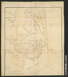
Albemarle and Pamlico Sounds
67.
Allegheny River and French Creek
68.
America, engraved according to recent geographical observations
69.
American camp at Valley Forge
70.
L'Amérique, divisée par grands etats
71.
L'Amérique Septentrionale
72.
Amérique Septentrionale divisée en ses principaux etats
73.
Amérique Septentrionale, Yorck : reconnoissance des ouvrages de cette ville ave le tracé des attaques dirigées contre eux
74.
The attack and defeat of the American fleet under Benedict Arnold, by the kings fleet commanded by Captn. Thos. Pringle, upon...
75.
Attack of the rebels upon Fort Penobscot in the province of New England in which their fleet was totally destroyed and their...
76.
Attaque de la ville d'York en Virginie prise le 19 8bre 1781 par les armées combinées de France et d'Amérique
77.
Attaques des forts de Chouaguen en Amérique pris par les français commandés par le Marquis de Montcalm le 14 Août 1756
78.
Attaques des retranchemens devant le fort Carillon en Amérique par les anglais commandés par le général Abercrombie contre les...
79.
Attaques du fort William-Henri en Amérique par les troupes français aux ordres du Marquis de Montcalm prise de ce fort le 7...
80.
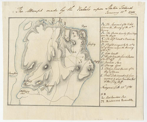
The attempt made by the rebels upon Staten Island January 15th 1780
‹ Prev
Next ›
1
2
3
4
5
6
7
8
…
47
48