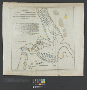
Attack of the rebels upon Fort Penobscot in the province of New England in which their fleet was totally destroyed and their army dispersed the 14th Augst. 1779
This map is also available in American Revolutionary Geographies Online (ARGO), a collections portal especially built for material relating to the American Revolutionary War Era. Visit ARGO to learn more about this item and explore the historical geography of North America in the late eighteenth century.
Item Information
- Title:
- Attack of the rebels upon Fort Penobscot in the province of New England in which their fleet was totally destroyed and their army dispersed the 14th Augst. 1779
- Name on Item:
-
by an officer present
- Date:
-
December 18, 1785
- Format:
-
Maps/Atlases
- Location:
- William L. Clements Library
- Collection (local):
-
William L. Clements Library Collection
- Subjects:
-
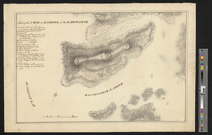
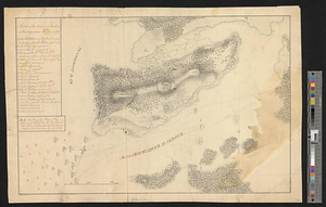
Castine (Me.)--Maps
Fort George (Me. : Fort)--Maps
United States--History--Revolution, 1775-1783--Maps
Penobscot expedition, 1779--Maps
- Places:
-
MaineHancock (county)Castine
- Extent:
- 1 map : col. ; 36.1 x 38.3 cm.
- Terms of Use:
-
The University of Michigan Library provides access to these materials for educational and research purposes. These materials may be under copyright. If you decide to use any of these materials, you are responsible for making your own legal assessment and securing any necessary permission. If you have questions about the collection, please contact the William L. Clements Library.
Contact host institution for more information.
- Place of origin:
-
[London]
- Scale:
-
Scale ca. 1:14,700.
- Language:
-
English
- Catalog Record:
-
Catalog record
- Notes:
-
Below neat line: For the continuation (after Tindal's) of Rapin's History of Engd.
From: Rapin-Thoyras, Paul de. Rapin's impartial history of England ..., 1784-89.
Text block provides information on the American attack of 1779.
Ships shown in various positions and identified by name.
- Identifier:
-
839
- Barcode:
-
B1937609