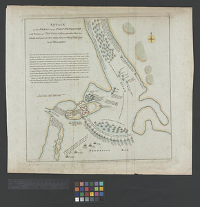
A front view of Fort George Majabigwaduce June 1780

This map is also available in American Revolutionary Geographies Online (ARGO), a collections portal especially built for material relating to the American Revolutionary War Era. Visit ARGO to learn more about this item and explore the historical geography of North America in the late eighteenth century.
Item Information
- Title:
- A front view of Fort George Majabigwaduce June 1780
- Creator:
- Jones, George Walker Dyall (Dyail)
- Date:
-
June 1780
- Format:
-
Maps/Atlases
- Genre:
-
Manuscript maps
- Location:
- William L. Clements Library
- Collection (local):
-
William L. Clements Library Collection
- Subjects:
-
Fort George (Me. : Fort)--Maps
Castine (Me.)--Maps
United States--History--Revolution, 1775-1783--Maps
- Places:
-
MaineHancock (county)Castine
- Extent:
- 1 ms. map : gray wash ; 50.5 x 71 cm.
- Terms of Use:
-
The University of Michigan Library provides access to these materials for educational and research purposes. These materials may be under copyright. If you decide to use any of these materials, you are responsible for making your own legal assessment and securing any necessary permission. If you have questions about the collection, please contact the William L. Clements Library.
Contact host institution for more information.
- Scale:
-
Scale 1:1,200.
- Language:
-
English
- Catalog Record:
-
Catalog record
- Notes:
-
Finished, pen and ink plan and drawing including ground plan, section, and elevation of fort.
Table of references identifies features of fort.
Very similar to Clinton 33, A plan, profile and front view of Fort George ...
Clinton Maps 34.
- Identifier:
-
838
- Barcode:
-
B1937588