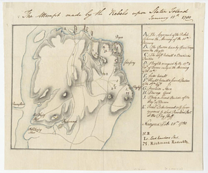
The attempt made by the rebels upon Staten Island January 15th 1780
This map is also available in American Revolutionary Geographies Online (ARGO), a collections portal especially built for material relating to the American Revolutionary War Era. Visit ARGO to learn more about this item and explore the historical geography of North America in the late eighteenth century.
Item Information
- Title:
- The attempt made by the rebels upon Staten Island January 15th 1780
- Creator:
- Martin, Reinhard Jacob
- Date:
-
February 20, 1780
- Format:
-
Maps/Atlases
- Genre:
-
Manuscript maps
- Location:
- William L. Clements Library
- Collection (local):
-
William L. Clements Library Collection
- Subjects:
-
Staten Island (New York, N.Y.)--Maps
United States--History--Revolution, 1775-1783--Maps
- Places:
-
New YorkRichmond (county)Staten Island (island)
- Extent:
- 1 ms. map : col. ; 19.5 x28 cm
- Terms of Use:
-
The University of Michigan Library provides access to these materials for educational and research purposes. These materials may be under copyright. If you decide to use any of these materials, you are responsible for making your own legal assessment and securing any necessary permission. If you have questions about the collection, please contact the William L. Clements Library.
Contact host institution for more information.
- Scale:
-
Scale indeterminate.
- Language:
-
English
- Catalog Record:
-
Catalog record
- Notes:
-
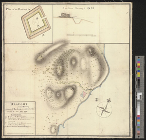
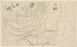
Finished, colored, topographical map showing movements of troops in American attack on British positions on Staten Island.
Table of references identifies individual units and movements.
Clinton Maps 363.
- Identifier:
-
1628
- Barcode:
-
B1938602