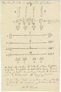
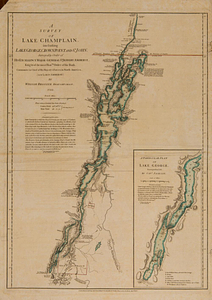
The attack and defeat of the American fleet under Benedict Arnold, by the kings fleet commanded by Captn. Thos. Pringle, upon Lake Champlain, the 11th of October, 1776 : from a sketch taken by an officer on the spot

This map is also available in American Revolutionary Geographies Online (ARGO), a collections portal especially built for material relating to the American Revolutionary War Era. Visit ARGO to learn more about this item and explore the historical geography of North America in the late eighteenth century.
Item Information
- Title:
- The attack and defeat of the American fleet under Benedict Arnold, by the kings fleet commanded by Captn. Thos. Pringle, upon Lake Champlain, the 11th of October, 1776 : from a sketch taken by an officer on the spot
- Contributor:
- Faden, William, 1749-1836
- Date:
-
December 3, 1776
- Format:
-
Maps/Atlases
- Location:
- William L. Clements Library
- Collection (local):
-
William L. Clements Library Collection
- Subjects:
-
Valcour Island, Battle of, N.Y., 1776--Maps
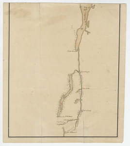
Champlain, Lake--Maps
United States--History--Revolution, 1775-1783--Maps
- Places:
-
Champlain, Lake
- Extent:
- 1 map : outline col. ; 47 x 42 cm.
- Terms of Use:
-
The University of Michigan Library provides access to these materials for educational and research purposes. These materials may be under copyright. If you decide to use any of these materials, you are responsible for making your own legal assessment and securing any necessary permission. If you have questions about the collection, please contact the William L. Clements Library.
Contact host institution for more information.
- Publisher:
-
London :
Wm. Faden, Charing Cross
- Scale:
-
Scale 1:70,000.
- Language:
-
English
- Catalog Record:
-
Catalog record
- Notes:
-
State 2 with Guy Carleton's name replaced by Thomas Pringle as commander.
This variant includes letterpress text below map entitled: An account of the expedition of the British fleet on Lake Champlain, under the command of Captain Thomas Pringle, and the defeat of the rebel fleet, commanded by Benedict Arnold, on the 11th and 13th of October, 1776.
Engraved by: Wm. Faden, Charing Cross.
Map shows positions and movements of British and American fleets in Battle of Valcour Island.
British vessels identified by name.
Text provides names and armaments of individual vessels, the names of British commanding officers, and an account of the action.
- Identifier:
-
784
- Barcode:
-
B2819877