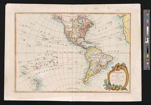
America, engraved according to recent geographical observations
This map is also available in American Revolutionary Geographies Online (ARGO), a collections portal especially built for material relating to the American Revolutionary War Era. Visit ARGO to learn more about this item and explore the historical geography of North America in the late eighteenth century.
Item Information
- Title:
- America, engraved according to recent geographical observations
- Title (alt.):
-
Arctic region
- Creator:
- Endasian, Elia
- Date:
-
1787
- Format:
-
Maps/Atlases
- Location:
- William L. Clements Library
- Collection (local):
-
William L. Clements Library Collection
- Subjects:
-
Western Hemisphere--Maps
- Places:
-
Americas (area)
- Extent:
- 1 map : outline col. ; 46.4 x 63.5 cm.
- Terms of Use:
-
The University of Michigan Library provides access to these materials for educational and research purposes. These materials may be under copyright. If you decide to use any of these materials, you are responsible for making your own legal assessment and securing any necessary permission. If you have questions about the collection, please contact the William L. Clements Library.
Contact host institution for more information.
- Publisher:
-
[Venice] :
[St. Lazarus Monastery]
- Scale:
-
Scale 1:10,000,000.
- Language:
-
Armenian
- Catalog Record:
-
Catalog record
- Notes:
-
Title and legends in Armenian.
Done by fathers of the Michitarist order on the island of San Lazaro.
- Identifier:
-
817
- Barcode:
-
B1939561