Toggle navigation
LMEC Home
Exhibitions
Georeferencing
Tools for Teachers
Collections
My Favorites
Sign Up / Log In
Search
Search the map portal
Map Collection
Map Collection
Map Sets
Search
Search
Search for
Search In
All Fields
Creator
Title
Subject
Place
Search All Digital Collections
Advanced Search
995 Results
My Search
Start Over
More Like
commonwealth-oai:0g358d519
Remove constraint More Like: commonwealth-oai:0g358d519
Filter your Search
Place
North and Central America
958
United States
638
Canada
209
New York
192
Quebec
111
North America
96
Pennsylvania
60
New Jersey
54
more
Place
»
Topic
United States--History--Revolution, 1775-1783--Maps
306
United States--History--French and Indian War, 1754-1763--Maps
149
North America--Maps
85
Saint Lawrence River--Maps
46
Newport (R.I.)--Maps
27
New York (State)--Maps
24
United States--Maps
23
Hudson River (N.Y. and N.J.)--Maps
21
more
Topic
»
Date
Date range begin
–
Date range end
Current results range from
1700
to
1945
View distribution
Creator
Rocque, Mary Ann
29
Bellin, Jacques Nicolas, 1703-1772
25
Holland, Samuel, 1728-1801
25
Jefferys, Thomas, -1771
25
Montrésor, John, 1736-1799
25
Clinton, Henry, Sir, 1738?-1795
19
Robert Sayer and John Bennett (Firm)
16
Kitchin, Thomas, 1719-1784
14
more
Creator
»
Format
Maps/Atlases
979
Drawings/Illustrations
11
Documents
5
Prints
1
Georeferenced
Yes
14
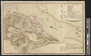
No
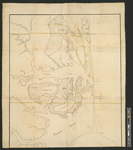
981
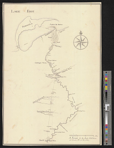
Collection
American Revolutionary War-Era Maps
942
William L. Clements Library Collection
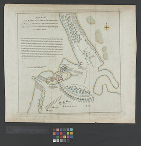
909
Norman B. Leventhal Map & Education Center Collection
53
Maps from AAS
17
New York Public Library Collection
9
MacLean Collection Map Library
6
Richard H. Brown Revolutionary War Map Collection at Mount Vernon
1
Available to use
No known restrictions
53
Creative Commons license
11
Search Constraints
Sort by relevance
relevance
title
date (asc)
date (desc)
Number of results to display per page
20 per page
10
per page
20
per page
50
per page
100
per page
View results as:
grid view
map view
Search Results
101.
Thermal map of North America, delineating the isothermal zodiac, the isothermal axis of intensity, and its expansions up and...
102.
15 lots of 440a each in Great Lot no. 4 of Macomb purchase : 6600 acres within 2 miles of the St. Lawrence Turnpike & 1/2 mile...
103.
The above is a connection of the three surveys which I have been able to make on Peters Creek, of yours to gether with John...
104.
An accurate map of Canada, with the adjacent countries; exhibiting the late seat of war between the English & French in those...
105.
An accurate map of New York in North America from a late survey
106.
An accurate map of the British empire in Nth. America as settled by the preliminaries in 1762
107.
An accurate map of the island of St. Christophers, from an actual survey; shewing the parishes, churches; and rivers; also the...
108.
An accurate map of the West Indies : exhibiting not only all the islands possess'd by the English, French, Spaniards & Dutch...
109.
An accurate map of the West Indies, containing the Bahama & Caribbe islands the Great & Little Antilles; with the Leward and...
110.
Action between Genl. St Clairs army & that of the American Indians Novr. 4th 1791 : collected from his public letter
111.
Admiral George Clinton's lands in the "Oblong"
112.
Affaire de Monmouth ce 28me Juin 1778
113.
Albemarle and Pamlico Sounds
114.
Allegheny River and French Creek
115.
American camp at Valley Forge
116.
Amérique Septentrionale, Yorck : reconnoissance des ouvrages de cette ville ave le tracé des attaques dirigées contre eux
117.
The attack and defeat of the American fleet under Benedict Arnold, by the kings fleet commanded by Captn. Thos. Pringle, upon...
118.
Attack of the rebels upon Fort Penobscot in the province of New England in which their fleet was totally destroyed and their...
119.
Attaque de la ville d'York en Virginie prise le 19 8bre 1781 par les armées combinées de France et d'Amérique
120.
Attaques des forts de Chouaguen en Amérique pris par les français commandés par le Marquis de Montcalm le 14 Août 1756
‹ Prev
Next ›
1
2
3
4
5
6
7
8
9
10
…
49
50