Toggle navigation
LMEC Home
Exhibitions
Georeferencing
Tools for Teachers
Collections
My Favorites
Sign Up / Log In
Search
Search the map portal
Map Collection
Map Collection
Map Sets
Search
Search
Search for
Search In
All Fields
Creator
Title
Subject
Place
Search All Digital Collections
Advanced Search
495 Results
My Search
Start Over
More Like
commonwealth:z603vg09g
Remove constraint More Like: commonwealth:z603vg09g
Filter your Search
Place
North and Central America
478
United States
413
Canada
64
North America
31
West Indies
23
Massachusetts
19
Great Lakes
17
New York
16
more
Place
»
Topic
United States--Maps
330
Canada--Maps
55
Elections--United States--Maps
36
Railroads--United States--Maps
34
North America--Maps
30
West Indies--Maps
24
Great Lakes (North America)--Maps
18
New England--Maps
15
more
Topic
»
Date
Date range begin
–
Date range end
Current results range from
1744
to
2023
View distribution
Creator
Paullin, Charles Oscar, 1868 or 1869-1944
70
Wright, John Kirtland, 1891-1969
70
Geological Survey (U.S.)
15
Bellin, Jacques Nicolas, 1703-1772
12
Reid, John, 1764?-1828
11
Kitchin, Thomas, 1719-1784
9
Carleton, Osgood, 1742-1816
8
Farwell, John Whittemore, 1843-1929
8
more
Creator
»
Format
Maps/Atlases
493
Manuscripts
13
Prints
2
Books
1
Objects/Artifacts
1
Posters
1
Georeferenced
Yes
77
No
418
Collection
Norman B. Leventhal Map & Education Center Collection
313
American Revolutionary War-Era Maps
181
Maps from AAS
138
William L. Clements Library Collection
33
MacLean Collection Map Library
10
Boston and New England Maps
3
Applied Geographics, Inc. Records
2
David Judkins Weaver Papers
2
more
Collection
»
Available to use
No known restrictions
238
Creative Commons license
6
Search Constraints
Sort by relevance
relevance
title
date (asc)
date (desc)
Number of results to display per page
20 per page
10
per page
20
per page
50
per page
100
per page
View results as:
grid view
map view
Search Results
201.
Map of the United States of America
202.
Map of the United States of America
203.
Map of the United States of America : including Canada and a large portion of Texas showing the base meridian and township...
204.
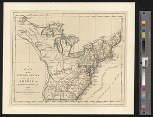
A map of the United States of America as settled by the peace of 1783
205.
Map of the United States of America, Mexico, Central America, and the West India Islands
206.
Map of the United States of America, the British Provinces, Mexico, the West Indies and Central America, with part of New...
207.
Map of the United States of America, the British provinces, Mexico, the West Indies and Central America, with part of New...
208.
Map of the United States of North America
209.
A map of the United States of North America : drawn from a number of critical researches
210.
Map of the United States of North America, upper & lower Canada, New Brunswick, Nova Scotia & British Columbia, Mexico, Cuba,...
211.
Map of the United States, showing by colors the area of freedom and slavery, and the territories whose destiny is yet to be...
212.
Map of the United States showing principal cities, rivers, and mountain ranges
213.
Map of the United States, the British provinces, Mexico, &c : showing the routes of the U.S. Mail steam packets to California,...
214.
Map of United States showing drainage areas and index numbers
215.
Map showing distribution of indian stocks and tribes, between 1710-1720
216.
Map showing in five degrees of density the distribution of woodland within the territory of the United States, 1873
217.
Map showing Indian reservations within the limits of the United States
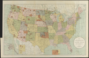
218.
Map showing Indian reservations within the limits of the United States, 1901
219.
Map showing Indian reservations within the limits of the United States, 1903
220.
Map showing Indian reservations within the limits of the United States, 1904
‹ Prev
Next ›
1
2
…
7
8
9
10
11
12
13
14
15
…
24
25