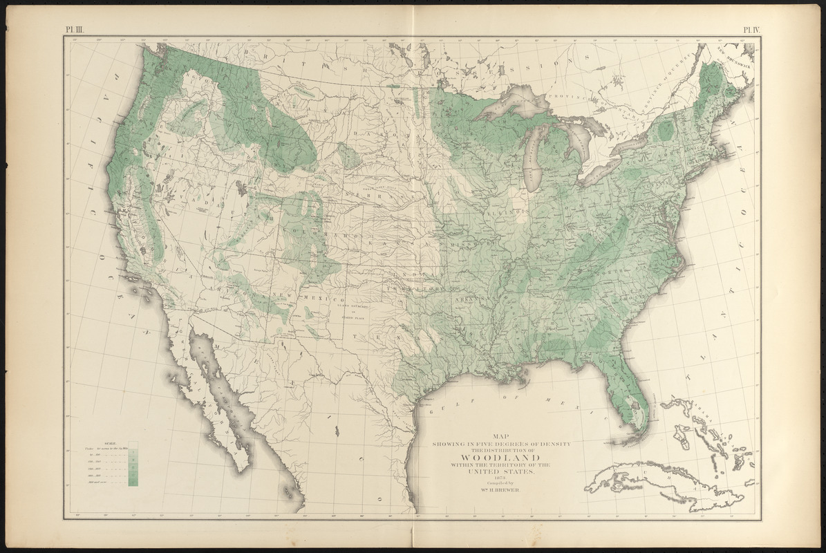
Map showing in five degrees of density the distribution of woodland within the territory of the United States, 1873
Item Information
- Title:
- Map showing in five degrees of density the distribution of woodland within the territory of the United States, 1873
- Description:
-
America Transformed: Reflecting growing concerns for the nation's diminishing natural resources as a result of individual ownership and overconsumption during the first half of the 19th century, this statistical map depicts forest density at the time of the 1870 census. The most extensive woodlands were in the East, along the northern Pacific Coast, and in the northern Rocky Mountains. Outside these forested areas were the grasslands of the Great Plains and the semi-arid scrub lands of the Southwest. Much of the East, which was originally very heavily forested, had less than 20-35 percent of the acreage in woodland after extensive deforestation.
- Compiler:
- Brewer, William Henry, 1828-1910
- Creator:
- United States. Census Office
- Lithographer:
- Julius Bien & Co.
- Name on Item:
-
compiled by Wm. H. Brewer
- Date:
-
[1874]
- Format:
-
Maps/Atlases
- Location:
-
Boston Public Library
Norman B. Leventhal Map & Education Center - Collection (local):
-
Norman B. Leventhal Map & Education Center Collection
- Subjects:
-
Forests and forestry--United States--Maps
United States--Maps
United States--Census, 1870
- Places:
-
United States
- Extent:
- 1 map : color ; 49 x 71 cm, on sheet 56 x 84 cm
- Terms of Use:
-
No known copyright restrictions.
No known restrictions on use.
- Publisher:
-
[New York] :
[Julius Bien, lith.]
- Scale:
-
Scale approximately 1:7,200,000
- Language:
-
English
- Notes:
-
From Statistical atlas of the United States based on the results of the ninth census 1870 / Francis A. Walker. New York : Julius Bien, lith., 1874.
In upper margin: Pl. III, Pl. IV.
- Notes (date):
-
This date is inferred.
- Notes (exhibitions):
-
Exhibited: "America transformed. Part 2: homesteads to modern cities," organized by the Norman B. Leventhal Map & Education Center at the Boston Public Library, 2019-2020.
- Identifier:
-
06_01_016801
- Call #:
-
G3701.D2 1874 .B74
- Barcode:
-
39999085953394