Maps showing the range, and, within the range, the degree of cultivation of certain principal crops
Item Information
- Title:
- Maps showing the range, and, within the range, the degree of cultivation of certain principal crops
- Description:
-
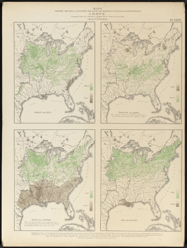
America Transformed: Agricultural production in the eastern United States is represented by this plate from the statistical atlas illustrating the 1870 census. There are four maps, each showing the distribution and degree of cultivation of two major crops. As the first national atlas, this prize-winning volume was a landmark publication displaying an unprecedented number of visual statistics and thematic maps. It was compiled by Francis Amasa Walker, Superintendent of the ninth and tenth censuses (taken in 1870 and 1880) and Commissioner of Indian Affairs (1871-1872). Walker transformed the census, acquiring and tabulating vast quantities of geographic information about the rapidly expanding country. However, this furthered the ability of the federal government to manage and control "the Indian as an obstacle to the national progress," as Walker described Native tribes in 1879.
- Compiler:
- Walker, Francis Amasa, 1840-1897
- Creator:
- United States. Census Office
- Lithographer:
- Julius Bien & Co.
- Name on Item:
-
compiled from the statistics of agriculture, Ninth census, 1870, by Francis A. Walker
- Date:
-
[1874]
- Format:
-
Maps/Atlases
- Location:
-
Boston Public Library
Norman B. Leventhal Map & Education Center - Collection (local):
-
Norman B. Leventhal Map & Education Center Collection
- Subjects:
-
Crops--United States--Maps
Agriculture--United States--Maps
Farms--United States--Maps
United States--Maps
United States--Census, 1870
- Places:
-
United States
- Extent:
- 4 maps on 1 sheet : color ; sheet 57 x 43 cm
- Terms of Use:
-
No known copyright restrictions.
No known restrictions on use.
- Publisher:
-
[New York] :
[Julius Bien, lith.]
- Scale:
-
Scale approximately 1:14,300,000
- Language:
-
English
- Table of Contents:
-
Wheat and rice
Tobacco and hops
Oats and cotton
Hay and sugar.
- Notes:
-
From Statistical atlas of the United States based on the results of the ninth census 1870 / Francis A. Walker. [New York]: Julius Bien, lith., 1874.
"Pl. XXXVI."
- Notes (date):
-
This date is inferred.
- Notes (exhibitions):
-
Exhibited: "America transformed. Part 2: homesteads to modern cities," organized by the Norman B. Leventhal Map & Education Center at the Boston Public Library, 2019-2020.
Exhibited: "America Transformed. Part 2: Homesteads to Modern Cities," organized by the Norman B. Leventhal Map & Education Center at the Boston Public Library, 2019-2020.
- Identifier:
-
06_01_016800
- Call #:
-
G3701.J6 1874 .U55
- Barcode:
-
39999085953402


