Toggle navigation
LMEC Home
Exhibitions
Georeferencing
Tools for Teachers
Collections
My Favorites
Sign Up / Log In
Search
Search the map portal
Map Collection
Map Collection
Map Sets
Search
Search
Search for
Search In
All Fields
Creator
Title
Subject
Place
Search All Digital Collections
Advanced Search
192 Results
My Search
Start Over
More Like
commonwealth:z603vg000
Remove constraint More Like: commonwealth:z603vg000
Filter your Search
Place
North and Central America
158
United States
101
Southern United States
27
South Carolina
26
Charleston
23
Charleston (county)
23
Canada
22
West Indies
18
more
Place
»
Topic
Southern States--Maps
29
United States--History--Revolution, 1775-1783--Maps
29
Charleston (S.C.)--Maps
23
United States--Maps
20
West Indies--Maps
18
North America--Maps
17
Canada--Maps
14
Boston (Mass.)--Maps
9
more
Topic
»
Date
Date range begin
–
Date range end
Current results range from
1750
to
1978
View distribution
Creator
Reid, John, 1764?-1828
11
Farwell, John Whittemore, 1843-1929
9
Kitchin, Thomas, 1719-1784
9
Bellin, Jacques Nicolas, 1703-1772
8
Carleton, Osgood, 1742-1816
6
Tanner, Benjamin, 1775-1848
6
Anderson, Alexander, 1775-1870
5
Gibson, J. (John), active 1750-1792
5
more
Creator
»
Format
Maps/Atlases
192
Manuscripts
12
Georeferenced
Yes
16
No
176
Collection
American Revolutionary War-Era Maps
168
American Antiquarian Society Collection
138
William L. Clements Library Collection
28
Norman B. Leventhal Map & Education Center Collection
23
MacLean Collection Map Library
2
Boston and New England Maps
1
Maritime Charts and Atlases
1
New York Public Library Collection
1
Available to use
No known restrictions
23
Creative Commons license
2
Search Constraints
Sort by relevance
relevance
title
date (asc)
date (desc)
Number of results to display per page
20 per page
10
per page
20
per page
50
per page
100
per page
View results as:
grid view
map view
Search Results
1.
A general map of the southern British colonies in America comprehending North and South Carolina, Georgia, East and West...
2.
A Plan of Charles Town the capitol of South Carolina, : with the harbour, islands, and forts; the attack on Fort Sulivan, by...
3.
Various plans and draughts of cities, towns, harbours &c. drawn from the latest authorities
4.
Carolinae Floridae nec non insularum Bahamensium : cum partibus adjacendibus delineatio ad Exemplar Londinense in lucem edita a...
5.
Carte de la Louisiane et de la Floride
6.
Florida from the latest authorities
7.
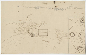
Plan of ground about Wilmington
8.
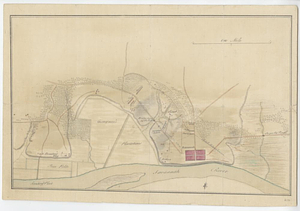
British capture of Savannah
9.
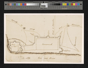
Map of the city of Savannah and vicinity
10.
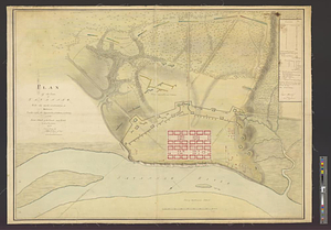
Plan of the decent [sic] and action of the 29th Decr. 1778, near the town of Savannah; by his majestys forces, under the...
11.
Plan of the town of Savannah, with the works constructed for its defence, together with the approaches & batteries of the...
12.
Proposed fortifications for Savannah
13.
Savannah and its defenses
14.
Savannah River and Savannah Sound
15.
Charles Town, South Carolina, with a chart of the bars & harbour
16.
Charleston and its approaches from the sea
17.
Charleston and the British attack of June 1776
18.
Disposition of the British forces before Charleston 1780
19.
Distribution & strength of corps 1780
20.
E. & G.W. Blunt's map of Charleston and vicinity
‹ Prev
Next ›
1
2
3
4
5
…
9
10


![Plan of the decent [sic] and action of the 29th Decr. 1778, near the town of Savannah; by his majestys forces, under the command of Lt. Colol. Campbell of the 71st Regt. foot](https://bpldcassets.blob.core.windows.net/derivatives/metadata/commonwealth-oai:qj72t576b/image_thumbnail_300.jpg)