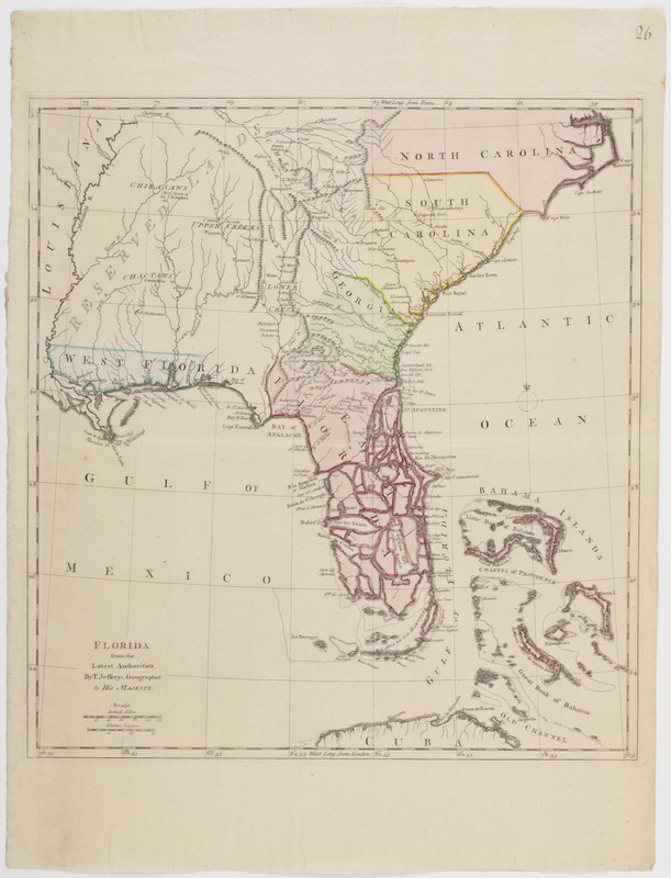
Florida from the latest authorities
This map is also available in American Revolutionary Geographies Online (ARGO), a collections portal especially built for material relating to the American Revolutionary War Era. Visit ARGO to learn more about this item and explore the historical geography of North America in the late eighteenth century.
Item Information
- Title:
- Florida from the latest authorities
- Description:
-
Subject: Map of the southeastern United States including North and South Carolina and Georgia as well as East and West Florida, and the "reserved lands" belonging to the Native Americans. The Bahama Islands are also seen off the coast of Florida.
- Creator:
- Jefferys, Thomas, -1771
- Name on Item:
-
by T. Jefferys, geographer to His Majesty.
- Date:
-
[1763]
- Format:
-
Maps/Atlases
- Location:
- American Antiquarian Society
- Collection (local):
-
American Antiquarian Society Collection
- Subjects:
-
Southern States--Maps
Florida--Maps
- Places:
-
Southern United States (area)
Florida
- Extent:
- 1 map : engraving, hand colored ; 39 x 36 cm., on sheet 51 x 38 cm.
- Terms of Use:
-
Public Domain/No known restrictions on use. Contact host institution to download image.
Contact host institution for more information.
- Publisher:
-
London :
[s.n.]
- Scale:
-
Scale [ca. 1:4,435,000]
- Language:
-
English
- Catalog Record:
-
http://catalog.mwa.org/vwebv/holdingsInfo?bibId=486430
- Notes:
-
Prime meridian: London and Ferro.
Relief shown pictorially.
From Roberts, W. Account of the first discovery, and natural history of Florida, London, ca. 1763.
- Notes (date):
-
This date is inferred.

![A map of West Florida and part of Et: Florida, Georgia part of So: Carolina i[n]cluding [torn] & Chactaw, Chickasaw & Creek nations with [torn] [r]oad [torn] Pensacola through ye: Creek nation to Augusitus & Charlestown](https://bpldcassets.blob.core.windows.net/derivatives/metadata/commonwealth-oai:v98001375/image_thumbnail_300.jpg)


