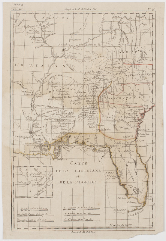
Carte de la Louisiane et de la Floride
This map is also available in American Revolutionary Geographies Online (ARGO), a collections portal especially built for material relating to the American Revolutionary War Era. Visit ARGO to learn more about this item and explore the historical geography of North America in the late eighteenth century.
Item Information
- Title:
- Carte de la Louisiane et de la Floride
- Description:
-
Subject: Map of Louisiana and Florida, also showing the southern states of Virginia, the Carolinas and Georgia. Also shows locations of various Native American tribes.
- Date:
-
[ca. 1780]
- Format:
-
Maps/Atlases
- Location:
- American Antiquarian Society
- Collection (local):
-
American Antiquarian Society Collection
- Subjects:
-
Southern States--Maps
Louisiana--Maps
Florida--Maps
- Places:
-
Florida
Louisiana
- Extent:
- 1 map : engraving, hand colored ; 32 x 21 cm., on sheet 34 x 24 cm.
- Terms of Use:
-
Public Domain/No known restrictions on use. Contact host institution to download image.
Contact host institution for more information.
- Publisher:
-
Geneva? :
[s.n.]
- Scale:
-
Scale [ca. 1:5,500,000]
- Language:
-
French
- Catalog Record:
-
http://catalog.mwa.org/vwebv/holdingsInfo?bibId=485297
- Notes:
-
Prime meridian: Paris and Ferro.
Relief shown pictorially.
Appears in Raynal, T. Atlas de toutes les parties connues du globe terrestre, Geneva, 1780.
"Liv. XVL no. 46."
![A map of West Florida and part of Et: Florida, Georgia part of So: Carolina i[n]cluding [torn] & Chactaw, Chickasaw & Creek nations with [torn] [r]oad [torn] Pensacola through ye: Creek nation to Augusitus & Charlestown](https://bpldcassets.blob.core.windows.net/derivatives/metadata/commonwealth-oai:v98001375/image_thumbnail_300.jpg)


