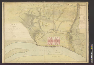
Plan of the town of Savannah, with the works constructed for its defence, together with the approaches & batteries of the enemy, and the joint attack of the French and rebels on the 9th of October, 1779 : from a survey
This map is also available in American Revolutionary Geographies Online (ARGO), a collections portal especially built for material relating to the American Revolutionary War Era. Visit ARGO to learn more about this item and explore the historical geography of North America in the late eighteenth century.
Item Information
- Title:
- Plan of the town of Savannah, with the works constructed for its defence, together with the approaches & batteries of the enemy, and the joint attack of the French and rebels on the 9th of October, 1779 : from a survey
- Contributor:
- Moncrieff, James, 1744-1793
- Creator:
- Wilson, John, 1755-1798
- Name on Item:
-
by John Wilson 71st Regt., asst. engineer
- Date:
-
[1779]
- Format:
-
Maps/Atlases
- Genre:
-
Manuscript maps
- Location:
- William L. Clements Library
- Collection (local):
-
William L. Clements Library Collection
- Subjects:
-
Savannah (Ga.)--Maps
Savannah (Ga.)--History--Siege, 1779--Maps
United States--History--Revolution, 1775-1783--Maps
- Places:
-
GeorgiaChatham (county)Savannah
- Extent:
- 1 ms. map : col. ; 74.2 x 97.7 cm.
- Terms of Use:
-
The University of Michigan Library provides access to these materials for educational and research purposes. These materials may be under copyright. If you decide to use any of these materials, you are responsible for making your own legal assessment and securing any necessary permission. If you have questions about the collection, please contact the William L. Clements Library.
Contact host institution for more information.
- Scale:
-
Scale 1:4,320.
- Language:
-
English
- Catalog Record:
-
Catalog record
- Notes:
-
Finished, colored, topographical map with the ground plan of the town and its fortifications, siege lines, and the disposition of the opposing forces.
Table of references gives armament of defenders' and attackers' batteries.
Signed within table of references by: James Moncrief, comdg. engineer.
Clinton Maps 325.
- Notes (date):
-
This date is inferred.
- Identifier:
-
8410
- Barcode:
-
B2644389
![Plan of the decent [sic] and action of the 29th Decr. 1778, near the town of Savannah; by his majestys forces, under the command of Lt. Colol. Campbell of the 71st Regt. foot](https://bpldcassets.blob.core.windows.net/derivatives/metadata/commonwealth-oai:qj72t576b/image_thumbnail_300.jpg)