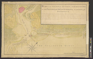
Charles Town, South Carolina, with a chart of the bars & harbour

This map is also available in American Revolutionary Geographies Online (ARGO), a collections portal especially built for material relating to the American Revolutionary War Era. Visit ARGO to learn more about this item and explore the historical geography of North America in the late eighteenth century.
Item Information
- Title:
- Charles Town, South Carolina, with a chart of the bars & harbour
- Contributor:
- Lodge, John, -1796
- Creator:
- Cowley, R
- Name on Item:
-
by R. Cowley
- Date:
-
June 1, 1780
- Format:
-
Maps/Atlases
- Location:
- William L. Clements Library
- Collection (local):
-
William L. Clements Library Collection
- Subjects:
-
Charleston (S.C.)--Maps
Charleston (S.C.)--Siege, 1776--Maps
United States--History--Revolution, 1775-1783--Maps
- Places:
-
South CarolinaCharleston (county)Charleston
- Extent:
- 1 map : col. ; 18.9 x 20 cm
- Terms of Use:
-
The University of Michigan Library provides access to these materials for educational and research purposes. These materials may be under copyright. If you decide to use any of these materials, you are responsible for making your own legal assessment and securing any necessary permission. If you have questions about the collection, please contact the William L. Clements Library.
Contact host institution for more information.
- Publisher:
-
[London] :
Fielding & Walker, Pater Noster Row
- Scale:
-
Scale indeterminate.
- Language:
-
English
- Catalog Record:
-
Catalog record
- Notes:
-
Engraved by: Jno. Lodge.
Map of Charleston harbor showing some fortifications and some features of British attack of 1776.
- Identifier:
-
5632
- Barcode:
-
B1939226